
Saline Creek (Mississippi River tributary) facts for kids
Quick facts for kids Saline Creek |
|
|---|---|

Saline Creek sign Route 61
|
|


|
|
| Country | United States |
| State | Missouri |
| Physical characteristics | |
| Main source | Perry County, MO 37°44′11″N 90°15′02″W / 37.73639°N 90.25056°W |
| River mouth | Mississippi River La Saline, MO 367 ft (112 m) 37°54′22″N 89°58′30″W / 37.90611°N 89.97500°W |
| Basin features | |
| Basin size | 75 sq mi (190 km2) |
Saline Creek is a stream in Missouri, USA. It starts in western Ste. Genevieve County. The creek then flows east, briefly going through northern Perry County. Finally, it empties into a part of the Mississippi River. This spot is north of St. Mary and across from Kaskaskia Island.
Contents
What's in a Name? The History of Saline Creek
The original French name for this stream was La Rivière de Saline. This means "The River of the Saltworks." This name came from two natural salt springs in the area. These springs also gave the name to the creek and its smaller streams, called Saline Creek or Saline River.
The French settlers called it La Rivière de la Saline or La Petite Rivière de la Saline. The Spanish called the creek and its branches Las Salinas.
Where is Saline Creek Located?
Saline Creek begins in western Ste. Genevieve County. It flows east and briefly enters northern Perry County. The creek then joins a part of the Mississippi River. This meeting point is near Kaskaskia Island, just north of St. Mary. It is about six miles south of Sainte Genevieve.
The spot where Saline Creek meets the Mississippi River is about 367 feet above sea level. The area of land that drains into Saline Creek, called its watershed, is about 75 square miles.
Smaller Streams Joining Saline Creek
Several smaller streams flow into Saline Creek. These are called tributaries:
- Brushy Creek
- Coldwater Creek
- Greasy Creek
- Johns Creek
- Little Saline Creek
- Madden Creek
- South Fork Saline Creek
Early Settlements Along Saline Creek
Two main settlements grew up along Saline Creek. These were called La Grande Saline and La Petite Saline. La Grande Saline was the larger of the two. People often just called it La Saline or sometimes Old Saline.
Two areas, called townships, were named after Saline Creek. These are Saline Township in Ste. Genevieve County and Saline Township in Perry County.
A Salty History: How Saline Creek Shaped the Past
Saline Creek has a long and interesting history, especially because of its salt springs.
Salt for Survival: Early Uses of Saline Creek
In 1541, a Spanish explorer named De Soto sent people to find salt. They went to a salty stream in the north, which was likely Saline Creek. Later, during the French colonial period, both French settlers and Illinois Native Americans came to Saline Creek to get salt.
Making Salt: The Main Purpose of the Settlements
Settlements along Saline Creek began in the early 1700s. By 1715, French groups were already making salt there. At first, these camps were temporary. But over time, they became permanent towns.
The two main settlements, Grande Saline and Petite Saline, focused on making salt. Salt was very important for preserving meat, tanning animal skins, and processing furs. The settlers would boil water from the salt springs in special ovens. As the water evaporated, the salt was left behind.
A Busy Place: Salt and Lead Trade
By 1800, French and American settlers were using four or five furnaces to extract salt. They sent about 3,500 barrels of salt to New Orleans each year.
Besides salt, La Saline was also a key place for shipping lead. Lead from Mine la Motte, a mine opened in the 1720s, was brought by animals or carts. It traveled over ridge roads and down the Saline River Valley to La Saline. From there, it was loaded onto boats on the Mississippi River.
Salt production continued for some time. In 1822, about seventeen workers were still using many kettles to get salt. However, by 1825, all salt production had stopped.
Images for kids
-
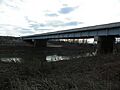
Highway 61 Bridge
-
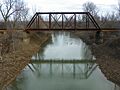
Railroad Bridge
-
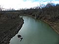
Saline Creek


