Salzburg-Umgebung District facts for kids
Quick facts for kids
Salzburg-Umgebung District
Bezirk Salzburg-Umgebung
|
|
|---|---|
| Country | Austria |
| State | Salzburg |
| Number of municipalities | 37 |
| Area | |
| • Total | 1,004.36 km2 (387.79 sq mi) |
| Population
(2009)
|
|
| • Total | 140,914 |
| • Density | 140.3023/km2 (363.3812/sq mi) |
| Time zone | UTC+01:00 (CET) |
| • Summer (DST) | UTC+02:00 (CEST) |
Salzburg-Umgebung is a special area in Austria. It is a district within the state of Salzburg. This district is also known as the Flachgau region.
The main city or "administrative center" of this district is Salzburg. This is where many important offices are located. The district covers an area of about 1,004 square kilometers. In 2009, about 140,914 people lived here.
Contents
How the District Is Organized
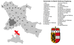
The Salzburg-Umgebung district is split into 37 smaller areas. These smaller areas are called municipalities. Among these, some are bigger towns and some are smaller villages.
There are three main towns in the district. There are also six special areas called market towns. The rest are regular municipalities.
Main Towns in Salzburg-Umgebung
These are the three largest towns in the district:
- Neumarkt am Wallersee (5,420 people)
- Oberndorf bei Salzburg (5,431 people)
- Seekirchen am Wallersee (9,344 people)
Important Market Towns
Market towns are places that have special rights. They can hold markets and often have a bit more importance than regular villages.
- Eugendorf (6,118 people)
- Grödig (6,638 people)
- Mattsee (2,850 people)
- Obertrum (4,208 people)
- Straßwalchen (6,752 people)
- Thalgau (6,712 people)
Other Municipalities
These are the other 28 municipalities in the district. They are smaller towns or villages.
- Anif (4,048 people)
- Anthering (3,108 people)
- Bergheim (4,839 people)
- Berndorf bei Salzburg (1,578 people)
- Bürmoos (4,418 people)
- Dorfbeuern (1,392 people)
- Ebenau (1,348 people)
- Elixhausen (2,681 people)
- Elsbethen (5,117 people)
- Faistenau (2,850 people)
- Fuschl am See (1,334 people)
- Göming (607 people)
- Großgmain (2,416 people)
- Hallwang (3,499 people)
- Henndorf am Wallersee (4,647 people)
- Hintersee (460 people)
- Hof bei Salzburg (3,405 people)
- Koppl (3,037 people)
- Köstendorf (2,453 people)
- Lamprechtshausen (3,140 people)
- Nußdorf am Haunsberg (2,176 people)
- Plainfeld (1,131 people)
- Sankt Georgen bei Salzburg (2,728 people)
- Sankt Gilgen (3,683 people)
- Schleedorf (882 people)
- Seeham (1,677 people)
- Strobl (3,453 people)
- Wals-Siezenheim (11,024 people)
- (Population numbers are from May 15, 2001.)
See also
 In Spanish: Distrito de Salzburg-Umgebung para niños
 | Madam C. J. Walker |
 | Janet Emerson Bashen |
 | Annie Turnbo Malone |
 | Maggie L. Walker |


