San Antonio, Quebradillas, Puerto Rico facts for kids
Quick facts for kids
San Antonio
|
|
|---|---|
|
Barrio
|
|

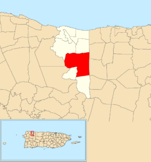
Location of San Antonio within the municipality of Quebradillas shown in red
|
|
| Commonwealth | |
| Municipality | |
| Area | |
| • Total | 6.08 sq mi (15.7 km2) |
| • Land | 6.08 sq mi (15.7 km2) |
| • Water | 0 sq mi (0 km2) |
| Elevation | 761 ft (232 m) |
| Population
(2010)
|
|
| • Total | 5,164 |
| • Density | 849.3/sq mi (327.9/km2) |
| Source: 2010 Census | |
| Time zone | UTC−4 (AST) |
San Antonio is a neighborhood, called a barrio, located in the town of Quebradillas, Puerto Rico. In 2010, about 5,164 people lived there. It's a part of the beautiful island of Puerto Rico, which is a commonwealth of the United States.
| Historical population | |||
|---|---|---|---|
| Census | Pop. | %± | |
| 1900 | 1,760 | — | |
| 1910 | 1,886 | 7.2% | |
| 1920 | 2,196 | 16.4% | |
| 1930 | 2,242 | 2.1% | |
| 1940 | 2,311 | 3.1% | |
| 1950 | 3,119 | 35.0% | |
| 1980 | 4,350 | — | |
| 1990 | 4,424 | 1.7% | |
| 2000 | 5,262 | 18.9% | |
| 2010 | 5,164 | −1.9% | |
| U.S. Decennial Census 1899 (shown as 1900) 1910-1930 1930-1950 1980-2000 2010 |
|||
Contents
A Look Back in Time
Puerto Rico used to be a part of Spain. After the Spanish–American War ended in 1898, Spain gave Puerto Rico to the United States. This happened because of a peace agreement called the Treaty of Paris of 1898.
Becoming a U.S. Territory
After the war, Puerto Rico became an unincorporated territory of the United States. This means it's a part of the U.S. but doesn't have all the same rights as a state. In 1899, the U.S. government counted the people living in Puerto Rico. They found that San Antonio barrio had 1,760 residents at that time.
Exploring San Antonio's Sectors
Barrios in Puerto Rico are like large neighborhoods or areas. These barrios are then divided into even smaller local places called sectores, which means "sectors" in English.
Types of Sectors
The names for these sectores can be different. Some are simply called sector, while others might be named urbanización (a type of housing development), reparto (a land division), barriada (a smaller neighborhood), or residencial (a residential area).
Main Areas of San Antonio
Here are some of the specific sectores you can find within San Antonio barrio:
- Calle Guelo Sonera
- Calle Pedro López
- Carretera Nueva
- Carretera 113
- Carretera 478
- Carretera 480
- Carretera 482
- Carretera 483
- Parcelas San Antonio (Pequeñas y Grandes)
- Sector Arizona
- Sector Barca de Oro (Negocio)
- Sector Casa de Piedra
- Sector El Fósforo
- Sector Guzmán
- Sector La Hacienda
- Sector La Rabúa
- Sector Los Romanes
- Sector Montadero
- Sector Palmarito
- Sector Piquiñas
See also
 In Spanish: San Antonio (Quebradillas) para niños
- List of communities in Puerto Rico
- List of barrios and sectors of Quebradillas, Puerto Rico
 | Aurelia Browder |
 | Nannie Helen Burroughs |
 | Michelle Alexander |


