San Cristóbal Verapaz facts for kids
Quick facts for kids
San Cristóbal Verapaz
|
||
|---|---|---|
|
Municipality
|
||

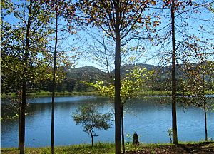
Chicoj Lake in San Cristóbal Verapaz
|
||
|
||
| Country | ||
| Department | Alta Verapaz Department | |
| Area | ||
| • Total | 163 sq mi (423 km2) | |
| Population
(2018 census)
|
||
| • Total | 68,819 | |
| • Density | 421.4/sq mi (162.69/km2) | |
| Climate | Cfb | |
San Cristóbal Verapaz is a town and a larger area called a municipality in Guatemala. It is located in the Alta Verapaz Department. The town itself had about 20,961 people in 2018. The whole municipality had about 68,819 people.
San Cristóbal Verapaz is about 29 kilometers (18 miles) from Cobán. Cobán is the capital city of Alta Verapaz. It is also about 210 kilometers (130 miles) from Guatemala City. The people in San Cristóbal mainly speak the Pokimchi' language. The town's main way of making money is from the "Cobán" shoe factory. This factory makes rubber boots for workers. These boots are sold in Guatemala and other countries.
Contents
History of San Cristóbal Verapaz
The Northern Transversal Strip
Lua error in Module:Location_map at line 420: attempt to index field 'wikibase' (a nil value). The Northern Transversal Strip was an area created in 1970. The government wanted to use this land for farming. It was set up by a special law. This law said that certain towns were part of this farming development area.
San Cristóbal Verapaz was not directly in this Strip. However, it was very close to it. Because of this, the town was affected by the Guatemala Civil War. This war happened mostly in the Strip during the 1980s.
Festivals and Celebrations
San Cristóbal Verapaz has several religious celebrations and town fairs. These events are important for the community. They often happen in different neighborhoods.
| Dates | Neighborhood |
|---|---|
| 13–15 January | Esquipulas |
| 17–20 January | San Sebastian |
| 20–25 July | San Cristóbal |
| 24–26 April | San Felipe |
| 20–25 July | Santa Ana |
Famous People from San Cristóbal Verapaz
Some well-known people come from San Cristóbal Verapaz:
- Erick Barrondo: He won a silver medal in the Olympics in London in 2012. He is famous for race walking.
- Rodolfo Narciso Chavarría: He was a talented music composer.
Climate and Weather
San Cristóbal Verapaz has a mild climate. This means it is not too hot and not too cold. It is known as an oceanic climate (Cfb in the Köppen climate system).
| Climate data for San Cristóbal Verapaz | |||||||||||||
|---|---|---|---|---|---|---|---|---|---|---|---|---|---|
| Month | Jan | Feb | Mar | Apr | May | Jun | Jul | Aug | Sep | Oct | Nov | Dec | Year |
| Mean daily maximum °C (°F) | 21.7 (71.1) |
23.2 (73.8) |
24.8 (76.6) |
25.5 (77.9) |
25.4 (77.7) |
24.5 (76.1) |
23.9 (75.0) |
24.2 (75.6) |
24.1 (75.4) |
23.2 (73.8) |
22.3 (72.1) |
22.1 (71.8) |
23.7 (74.7) |
| Daily mean °C (°F) | 16.1 (61.0) |
17.1 (62.8) |
18.4 (65.1) |
19.4 (66.9) |
19.8 (67.6) |
19.9 (67.8) |
19.4 (66.9) |
19.4 (66.9) |
19.3 (66.7) |
18.5 (65.3) |
17.5 (63.5) |
16.9 (62.4) |
18.5 (65.2) |
| Mean daily minimum °C (°F) | 10.6 (51.1) |
11.1 (52.0) |
12.1 (53.8) |
13.4 (56.1) |
14.3 (57.7) |
15.3 (59.5) |
14.9 (58.8) |
14.6 (58.3) |
14.6 (58.3) |
13.9 (57.0) |
12.7 (54.9) |
11.7 (53.1) |
13.3 (55.9) |
| Average precipitation mm (inches) | 70 (2.8) |
45 (1.8) |
62 (2.4) |
59 (2.3) |
139 (5.5) |
300 (11.8) |
270 (10.6) |
238 (9.4) |
290 (11.4) |
244 (9.6) |
150 (5.9) |
79 (3.1) |
1,946 (76.6) |
| Source: Climate-Data.org | |||||||||||||
Geographic Location and Communities
The municipality of San Cristóbal Verapaz has many different communities. The main town area has five neighborhoods. The areas outside the town have 89 communities.
Types of Communities
The municipality is divided into different types of areas:
- One main town (villa)
- Six large settlements
- Fifty-seven small settlements
- Sixteen common land areas
- Five neighborhoods
- Four cantons (smaller divisions)
- Three residential areas
Important Locations
There are eighteen important populated places. These places are important because many people live there. They also have access to useful services.
| # | Main Locations | Nearby Places |
|---|---|---|
| 1. | Santa Ana neighborhood | Colonia El Petencito, Finca Nisnic, Cantón Oram, Colonia Paná, Santa Ana Pampur, Tucanjan, Pantup |
| 2. | San Sebastián neighborhood | Agua Bendita, Esquipulas neighborhood, San Cristóbal neighborhood, San Felipe neighborhood, Pankox, Venecia |
| 3. | Vista Hermosa | Chisiram, Villa Nueva |
| 4. | El Salmar | Agua Blanca, San Joaquín, San José Chitusul, Santa Ana Pan Kix, Chisiram, Villa Nueva, Vista Hermosa, Saqlik, Santa María |
| 5. | Chiyuc | Aquil Grande, Chilley, El Alfiler, Finca El Rosario, Caserío la Independencia, Caserío Panek, Pantocan |
| 6. | La Reforma | Pamac, Rexkix, Wachtuhq, Las Arrugas, La Esperanza |
| 7. | La Pacaya | Chirehtzulchituj, Chirexkiche, Chitj Panhux, Najtilabaj |
| 8. | Paniste | Pancaseu |
| 9. | San Lucas Chiacal | |
| 10. | San Inés Chicar | Las Victorias, Pancaseu, Panisté, Secoyon, Tinta |
| 11. | Baleu | Zacatón |
| 12. | Santa Elena | Saqixim, Quejá, Santa Rosa, Chepenal, Las Minas |
| 13. | Pampacche | Mexabaj, Panzal, San Sebastián El Refujio, Wachkob', Pambón Grande |
| 14. | El Rancho | Ceero Verde, Santa María Agua Blanca, Chiworrom, Chipozo, Chisiguan, Wachkuz, Pamboncito, Panajmay, Nuevo Panhux, Santa Cruz del Quetzal |
| 15. | Pantzimaj | Chicuz, Panhux, Cedral |
| 16. | La Providencia | Quixalito, Pampur La Providencia |
| 17. | Cumbre Pamuc | |
| 18. | Navidad |
Borders of the Municipality
San Cristóbal Verapaz shares its borders with other municipalities:
 |
Cobán, municipality of Alta Verapaz Department | Cobán, municipality of Alta Verapaz |  |
|
| Chicamán, municipality of Quiché Department | Santa Cruz Verapaz, municipality of Alta Verapaz Department | |||
| Chicamán, municipality of Quiché Department |
See also
 In Spanish: San Cristóbal Verapaz para niños
 | Janet Taylor Pickett |
 | Synthia Saint James |
 | Howardena Pindell |
 | Faith Ringgold |


