
San Jacinto, Uruguay facts for kids
Quick facts for kids
San Jacinto
|
|
|---|---|
|
City & Municipality
|
|
 |
|

San Jacinto, Uruguay
Location in Uruguay
|
|
| Country | |
| Department | |
| Population
(2011 Census)
|
|
| • Total | 4,510 |
| Time zone | UTC -3 |
| Postal code |
91300
|
| Dial plan | +598 4399 (+4 digits) |
San Jacinto is a small, lively city in the southern part of Uruguay. It's located in the Canelones Department. The name "San Jacinto" also refers to the larger area, or municipality, that the city is part of.
Contents
Where is San Jacinto?
Finding San Jacinto on the Map
San Jacinto is easy to find! It sits right where two important roads, Route 7 and Route 11, cross paths. This city is about 53 kilometers (around 33 miles) northeast of Montevideo, which is the capital city of Uruguay.
San Jacinto's Journey Through Time
San Jacinto has grown a lot over the years! It started as a small settlement and gradually became a bigger place.
- In 1901, it was officially recognized as a "pueblo," which means a village.
- Then, in 1951, it grew even more and became a "Villa," or a town.
- Finally, in 1976, San Jacinto reached its current status and was officially named a "Ciudad," which means a city. This shows how much the community has developed!
How Many People Live in San Jacinto?
In 2011, a count of all the people (called a census) showed that 4,510 people lived in San Jacinto. A few years before, in 2010, the local government of Canelones thought the larger area (the municipality) had about 7,052 people.
Population Changes Over Time
The number of people living in San Jacinto has changed quite a bit through the years. Here's a quick look at how the population has grown:
| Year | Population |
|---|---|
| 1908 | 4,616 |
| 1963 | 1,908 |
| 1975 | 2,244 |
| 1985 | 2,795 |
| 1996 | 3,596 |
| 2004 | 3,909 |
| 2011 | 4,510 |
The information above comes from the Instituto Nacional de Estadística de Uruguay, which is like the national statistics office.
Places to Visit
St. Hyacinth Parish Church
One important building in San Jacinto is the St. Hyacinth Parish Church. This is a Roman Catholic church where people go to worship.
Images for kids
-
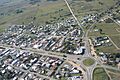
An aerial view showing the intersection of Route 7 and Route 11 in San Jacinto.
See also

- In Spanish: San Jacinto (Uruguay) for kids
