
San Rafael, Mendoza facts for kids
Quick facts for kids
San Rafael
|
|
|---|---|

San Rafael
|
|

San Rafael
Location in Argentina
|
|
| Country | |
| Province | |
| Department | San Rafael |
| Founded | 2 April 1805 |
| Elevation | 750 m (2,460 ft) |
| Population
(2010 census)
|
|
| • Total | 118,009 |
| Demonym(s) | sanrafaelino |
| Time zone | UTC−3 (ART) |
| CPA base |
M5600
|
| Dialing code | +54 0260 |
| Climate | BSk |
| Website | Official website: http://www.sanrafael.gov.ar/sitiooficial/ |
San Rafael is a lively city in the southern part of the Mendoza Province in Argentina. It is home to more than 118,000 people, making it the largest city in its area. San Rafael is also the main city of the San Rafael Department.
The city is about 240 kilometers (149 miles) from Mendoza, the capital city of the province. It's also about 990 kilometers (615 miles) from Buenos Aires, Argentina's federal capital. San Rafael is famous for its beautiful natural spots. These include the Diamante River, which flows right through the city. Just south of the city, you'll find the Atuel River with its exciting rapids. There's also Lake Los Reyunos, located about 20 kilometers (12 miles) west of San Rafael.
Contents
History of San Rafael

Spanish explorers first visited the San Rafael area in 1551. They were led by Francisco de Villagra and came from what is now Chile. They found that local people, like the Coquimbo and Diaguita cultures, were already farming well. The Spanish quickly took control of the land.
However, the Pehuenche people, who had been displaced, fought back. They attacked many times. In 1804, a peace agreement was signed with Viceroy Rafael de Sobremonte. The Pehuenches agreed to give some land to the Spanish authorities.
Founding the Fort
The construction of Fort San Rafael del Diamante began soon after. It was finished on April 2, 1805. This date marks the official start of San Rafael as a settlement. For a long time after Argentina became independent in 1816, San Rafael remained quite isolated.
Growth and Development
Eventually, the government realized how good the land was for farming. They also saw its important location. In 1871, a civil engineer named Julio Balloffet was put in charge of developing San Rafael. He focused on building important public structures. These included government buildings, schools, town squares, a hospital, and a cathedral.
He also worked on irrigation systems to bring water to farms. Along with these canals, an agricultural lab was set up. Experts helped farmers grow crops better. By 1900, the fruit farms in San Rafael had attracted many immigrants from Italy and France.
Becoming a City
Because of this sudden growth, San Rafael was officially named a department seat in 1903. In November of that year, the growing railway system reached the city. The railways helped local industries that processed food grow. In 1922, San Rafael was officially called a "city."
The powerful Atuel River and Diamante River helped build many important hydroelectric dams in the area. These dams made San Rafael even more important for the economy and tourism in southern Mendoza Province. The first big dam, the Nihuiles Hydroelectric Dam, opened in 1953 on the Atuel River. This dam creates a lot of electricity. It also formed a huge lake, which is now a popular spot for fun activities and tourism.
Another important dam, Los Reyunos Dam, was built on the Diamante River, south of San Rafael. It opened in 1984. Since 1968, the city has also hosted car races at its La Paredes Autodrome. Many famous races, like the TC 2000 touring car racing competitions, have taken place there.
Geography
Climate of San Rafael
San Rafael has a cold semi-arid climate. This means it's generally dry, but not as hot as a desert. The summers are warm, and the winters are cool.
| Climate data for San Rafael Airport, Mendoza (1991–2020, extremes 1961–present) | |||||||||||||
|---|---|---|---|---|---|---|---|---|---|---|---|---|---|
| Month | Jan | Feb | Mar | Apr | May | Jun | Jul | Aug | Sep | Oct | Nov | Dec | Year |
| Record high °C (°F) | 43.3 (109.9) |
40.7 (105.3) |
38.0 (100.4) |
34.4 (93.9) |
33.7 (92.7) |
32.0 (89.6) |
28.0 (82.4) |
35.6 (96.1) |
35.0 (95.0) |
36.5 (97.7) |
39.8 (103.6) |
41.5 (106.7) |
43.3 (109.9) |
| Mean daily maximum °C (°F) | 31.8 (89.2) |
30.2 (86.4) |
27.4 (81.3) |
22.6 (72.7) |
18.5 (65.3) |
16.1 (61.0) |
15.4 (59.7) |
18.0 (64.4) |
20.5 (68.9) |
23.9 (75.0) |
27.6 (81.7) |
30.7 (87.3) |
23.6 (74.5) |
| Daily mean °C (°F) | 23.8 (74.8) |
22.0 (71.6) |
19.4 (66.9) |
14.6 (58.3) |
10.7 (51.3) |
7.7 (45.9) |
6.8 (44.2) |
9.1 (48.4) |
12.2 (54.0) |
16.0 (60.8) |
19.7 (67.5) |
22.6 (72.7) |
15.4 (59.7) |
| Mean daily minimum °C (°F) | 15.8 (60.4) |
14.7 (58.5) |
12.9 (55.2) |
8.6 (47.5) |
5.2 (41.4) |
1.9 (35.4) |
0.8 (33.4) |
2.3 (36.1) |
4.9 (40.8) |
8.2 (46.8) |
11.4 (52.5) |
14.2 (57.6) |
8.4 (47.1) |
| Record low °C (°F) | 4.3 (39.7) |
4.8 (40.6) |
−2.7 (27.1) |
−4.3 (24.3) |
−7.8 (18.0) |
−8.4 (16.9) |
−9.7 (14.5) |
−8.7 (16.3) |
−6.9 (19.6) |
−2.4 (27.7) |
−0.3 (31.5) |
1.5 (34.7) |
−9.7 (14.5) |
| Average precipitation mm (inches) | 54.2 (2.13) |
50.6 (1.99) |
40.2 (1.58) |
26.6 (1.05) |
21.3 (0.84) |
7.2 (0.28) |
11.1 (0.44) |
14.5 (0.57) |
21.5 (0.85) |
38.3 (1.51) |
36.2 (1.43) |
41.2 (1.62) |
362.9 (14.29) |
| Average precipitation days (≥ 0.1 mm) | 6.9 | 6.4 | 5.1 | 4.2 | 4.3 | 2.2 | 2.5 | 3.1 | 4.0 | 5.1 | 5.8 | 6.0 | 55.4 |
| Average snowy days | 0.0 | 0.0 | 0.0 | 0.1 | 0.2 | 0.2 | 0.9 | 1.0 | 0.4 | 0.1 | 0.0 | 0.0 | 2.8 |
| Average relative humidity (%) | 50.0 | 56.1 | 61.3 | 65.7 | 68.6 | 63.2 | 60.4 | 53.8 | 52.6 | 51.3 | 48.2 | 46.6 | 56.5 |
| Mean monthly sunshine hours | 275.9 | 243.0 | 226.3 | 198.0 | 170.5 | 159.0 | 186.0 | 204.6 | 198.0 | 241.8 | 261.0 | 263.5 | 2,627.6 |
| Mean daily sunshine hours | 8.9 | 8.6 | 7.3 | 6.6 | 5.5 | 5.3 | 6.0 | 6.6 | 6.6 | 7.8 | 8.7 | 8.5 | 7.2 |
| Percent possible sunshine | 73 | 73 | 64 | 64 | 59 | 51 | 52 | 61 | 55 | 62 | 68 | 71 | 63 |
| Source 1: Servicio Meteorológico Nacional | |||||||||||||
| Source 2: UNLP (percent sun 1971–1980) | |||||||||||||
Gallery
-
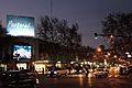
San Rafael's Downtown
-
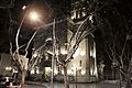
San Rafael's Cathedral
-
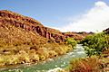
Atuel's River on Valle Grande
-
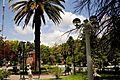
Plaza San Martin


See also
 In Spanish: San Rafael (Argentina) para niños
