San Rafael del Yuma facts for kids
Quick facts for kids
San Rafael del Yuma
|
||
|---|---|---|

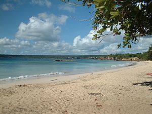
The beach of Boca de Yuma
|
||
|
||
| Country | Dominican Republic | |
| Province | La Altagracia | |
| Founded | 1608 | |
| Municipality since | 1904 | |
| Area | ||
| • Total | 981.2 km2 (378.8 sq mi) | |
| Elevation | 26 m (85 ft) | |
| Population | ||
| • Total | 46,687 | |
| • Density | 47.5815/km2 (123.236/sq mi) | |
| • Demonym | Yumense(a) | |
| Municipal Districts | 2 | |
San Rafael del Yuma is a town in the Dominican Republic. It is located in the La Altagracia province. About 46,687 people lived there in 2012.
This town is special because of its history. The old home of Juan Ponce de León is nearby. He was a famous Spanish explorer. His home's ruins are on a flat area called a plateau. This spot is just three kilometers from San Rafael del Yuma. The town is also close to Boca de Yuma, about 10 kilometers away.
Understanding San Rafael del Yuma's Weather
San Rafael del Yuma has a warm, tropical climate. Temperatures are usually hot all year round. The average high temperature is around 31.9 degrees Celsius (about 89 degrees Fahrenheit). The lowest temperatures are around 21.2 degrees Celsius (about 70 degrees Fahrenheit).
The town gets a good amount of rain each year. The rainiest months are typically May and October. During these months, there can be more thunderstorms. Even with the rain, there are many sunny days to enjoy.
Exploring the Areas of San Rafael del Yuma
San Rafael del Yuma is divided into 16 main areas. These areas are called sectors. Each sector is a part of the larger town. Here are the names of these sectors:
- Banda Abajo
- Bayahíbe
- Bejucal Abajo
- Boca del Yuma
- Cabo Falso
- Coral
- Gato
- Jaragua Abajo
- La Piñita
- Las Joyas del Mar
- Mata Chalupe
- Punta Papayo
- San José del Yuma
- San Rafael
- Yuma Abajo
- Yuma Arriba
See also
 In Spanish: San Rafael del Yuma para niños
 | William M. Jackson |
 | Juan E. Gilbert |
 | Neil deGrasse Tyson |


