
Sanare, Venezuela facts for kids
Quick facts for kids
Sanare
|
|
|---|---|
 |
|
.svg)
Sanare, Venezuela
Location in Venezuela
|
|
| Country | |
| State | Lara |
| Municipality | Andrés Eloy Blanco |
| Founded | 1620 |
| Elevation | 1,354 m (4,442 ft) |
| Population | |
| • Total | 48,764 |
| • Demonym | Sanareño/a |
| Time zone | VST |
| Postal code |
3018
|
| Area code(s) | 0253 |
Sanare is an important city in Lara State, Venezuela. It is the main city of the Andrés Eloy Blanco area. This area is divided into three smaller parts called parishes. Sanare is located in the Pio Tamayo parish.
The city of Sanare was started in the year 1620. A religious person named Dominico Melchor Ponce de Leon founded it. He was following orders from the governor at that time.
Geography and Climate
Sanare is located high up in the mountains. It sits about 1,357 meters (4,452 feet) above sea level.
The city has a climate that is quite wet. It gets a lot of rain, about 1,680 millimeters (66 inches) each year. The average temperature throughout the year is around 20 degrees Celsius (68 degrees Fahrenheit).
People and Population
Sanare has a population of about 39,052 people. This means there are about 56 people living in each square kilometer.
A large part of the population is young. Around 45.9% of the people in Sanare are younger than 15 years old.
Local Economy
The main way people in Sanare make a living is through agriculture. This means they grow crops.
The most important crop grown here is coffee. Farmers also grow other foods like potatoes, black beans, corn, and strawberries.
Images for kids
-
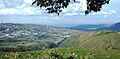
A view of Sanare in Lara State, Venezuela.
See also
 In Spanish: Sanare para niños
