Sandy, Pennsylvania facts for kids
Quick facts for kids
Sandy, Pennsylvania
|
|
|---|---|

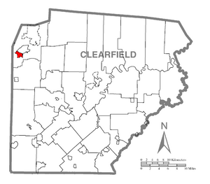
Location of Sandy in Clearfield County
|
|

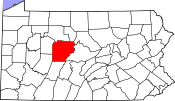
Location of Clearfield County in Pennsylvania
|
|
| Country | United States |
| State | Pennsylvania |
| County | Clearfield |
| Township | Sandy |
| Area | |
| • Total | 1.4 sq mi (3.6 km2) |
| • Land | 1.4 sq mi (3.6 km2) |
| Elevation | 1,430 ft (440 m) |
| Population
(2020)
|
|
| • Total | 1,362 |
| • Density | 1,031/sq mi (398.2/km2) |
| Time zone | UTC-5 (Eastern (EST)) |
| • Summer (DST) | UTC-4 (EDT) |
| ZIP code |
15801
|
| Area code(s) | 814 |
| FIPS code | 42-67784 |
| GNIS feature ID | 1193286 |
Sandy is a small community located in Clearfield County, Pennsylvania, in the United States. It is known as a census-designated place (CDP). This means it is an area identified by the U.S. Census Bureau for gathering statistics. In 2020, about 1,362 people lived in Sandy.
Contents
Geography of Sandy
Sandy is found in the northwestern part of Clearfield County. Its exact location is 41°6′31″N 78°46′21″W / 41.10861°N 78.77250°W. It sits right on the southern edge of the city of DuBois.
The community is part of Sandy Township. A major road, U.S. Route 219, goes through Sandy. This road leads north into DuBois and about 5 miles (8 km) southeast to Luthersburg.
Land and Water Area
According to the United States Census Bureau, the Sandy CDP covers a total land area of 3.6 square kilometers (about 1.4 square miles). Most of this area is land. Only a very small part, about 0.01 square kilometers (0.004 square miles), is water.
Population and People in Sandy
The number of people living in Sandy has changed over the years. Here's a quick look at the population counts from different census years:
| Historical population | ||
|---|---|---|
| Year | Pop. | ±% |
| 1990 | 1,795 | — |
| 2000 | 1,687 | −6.0% |
| 2010 | 1,429 | −15.3% |
| 2020 | 1,362 | −4.7% |
Who Lives in Sandy?
Based on the 2000 census, there were 1,687 people living in Sandy. These people made up 658 households, and 459 of these were families. The population density was about 1,203.5 people per square mile (464.7 people per square kilometer). This tells us how many people live in a certain amount of space.
Most of the people in Sandy were White (98.04%). A smaller number were African American (0.36%), Native American (0.12%), or Asian (0.83%). About 0.65% of the population identified as being from two or more races. A very small percentage (0.18%) were Hispanic or Latino.
Households and Families
Out of all the households, 28.0% had children under 18 living with them. Many households (57.1%) were married couples living together. About 9.9% were households led by a female without a husband present. The average household had 2.40 people, and the average family had 2.87 people.
Age Groups
The population in Sandy was spread out across different age groups:
- 21.0% were under 18 years old.
- 6.9% were between 18 and 24 years old.
- 27.2% were between 25 and 44 years old.
- 22.2% were between 45 and 64 years old.
- 22.7% were 65 years old or older.
The average age of people in Sandy was 42 years. For every 100 females, there were about 90.8 males.
Income Information
In 2000, the median income for a household in Sandy was $33,902. The median income for a family was $42,222. The per capita income for the community was $16,968. Per capita income is the average income per person.
See also
 In Spanish: Sandy (Pensilvania) para niños


