Sandyville, Ohio facts for kids
Quick facts for kids
Sandyville, Ohio
|
|
|---|---|

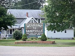
Sign at five-way intersection
|
|

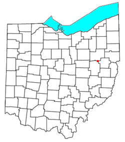
Location of Sandyville, Ohio
|
|
| Country | United States |
| State | Ohio |
| County | Tuscarawas |
| Township | Sandy |
| Elevation | 991 ft (302 m) |
| Population
(2020)
|
|
| • Total | 350 |
| Time zone | UTC-5 (Eastern (EST)) |
| • Summer (DST) | UTC-4 (EDT) |
| ZIP code |
44671
|
| GNIS feature ID | 2628966 |
Sandyville is a small community located in Tuscarawas County, Ohio, in the United States. It is considered an unincorporated community, which means it doesn't have its own local government like a city or town. However, it is also a census-designated place (CDP), which is a special area defined by the U.S. Census Bureau for gathering population data.
Sandyville has its own post office and uses the ZIP code 44671. You can find it along State Route 800, a road that connects Canton and New Philadelphia. In 2020, about 350 people lived in Sandyville.
History of Sandyville
Sandyville was first planned and mapped out in 1815. The community got its name from the nearby Sandy Creek. A post office opened in Sandyville in 1816, helping people send and receive mail.
Moving the Town Uphill
Originally, the village was located about half a mile south, right next to Sandy Creek. However, in the 1930s, a big change happened. The Muskingum Watershed Conservancy District announced plans to build several dams in the area. These dams would create floodplains, meaning the original town site would be at risk of flooding.
To keep the community safe, the people of Sandyville decided to move their entire town! Between 1937 and 1938, about 30 homes, the town hall, the post office, and several businesses were carefully moved uphill to the new, safer location where Sandyville stands today.
See also
 In Spanish: Sandyville (Ohio) para niños
 | Bayard Rustin |
 | Jeannette Carter |
 | Jeremiah A. Brown |

