Santa Ana Department facts for kids
Quick facts for kids
Santa Ana
|
|||
|---|---|---|---|
|
|||

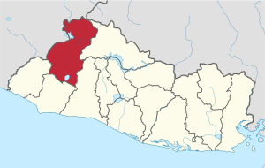
Location within El Salvador
|
|||
| Country | |||
| Created (given current status) |
1855 | ||
| Seat | Santa Ana | ||
| Area | |||
| • Total | 2,023.2 km2 (781.2 sq mi) | ||
| Population | |||
| • Total | 613,000 | ||
| • Rank | Ranked 4th | ||
| • Density | 302.99/km2 (784.7/sq mi) | ||
| Time zone | UTC−6 (CST) | ||
| ISO 3166 code | SV-SA | ||
Santa Ana is a large area, or "department," in the country of El Salvador. Think of a department like a state or a big region. Its main city, and also its capital, is called Santa Ana. This city is one of the biggest in all of El Salvador.
This department was created a long time ago in 1855. It was made official when José María San Martín was the president. Santa Ana is home to the famous Santa Ana Volcano. This area also has important rivers like the Lempa River and the Guajoyo River. You can find two big lakes here too: Lake Güija, which is right on the border with Guatemala, and Lake Coatepeque in the southern part.
Areas Inside Santa Ana
Santa Ana is divided into 13 smaller areas called municipalities. These are like smaller towns or districts within the department. Each municipality has its own local government and people living there.
| Municipality | Area (square kilometers) | Population (people) |
|---|---|---|
| Candelaria de la Frontera | 91.13 km² | 33,550 |
| Chalchuapa | 165.76 km² | 86,200 |
| Coatepeque | 126.85 km² | 48,544 |
| El Congo | 91.43 km² | 22,274 |
| El Porvenir | 52.52 km² | 7,819 |
| Masahuat | 71.23 km² | 5,125 |
| Metapán | 668.36 km² | 59,499 |
| San Antonio Pajonal | 51.92 km² | 4,574 |
| San Sebastián Salitrillo | 42.32 km² | 16,688 |
| Santa Ana | 400.05 km² | 261,568 |
| Santa Rosa Guachipilín | 38.41 km² | 7,909 |
| Santiago de la Frontera | 44.22 km² | 9,150 |
| Texistepeque | 178.97 km² | 20,904 |
See also
 In Spanish: Departamento de Santa Ana para niños
 | May Edward Chinn |
 | Rebecca Cole |
 | Alexa Canady |
 | Dorothy Lavinia Brown |


