
Coatepeque Caldera facts for kids
Quick facts for kids Coatepeque Caldera |
|
|---|---|
.jpg)
Satellite view of the Coatepeque Caldera
|
|
| Highest point | |
| Elevation | 746 m (2,448 ft) |
| Dimensions | |
| Length | 7 km (4.3 mi) |
| Width | 10 km (6.2 mi) |
| Naming | |
| Native name | Cōātepēc (Pipil) (Pipil) |
| English translation | "at the snake hill" |
| Geography | |

Coatepeque Caldera
Location in El Salvador
|
|
| Country | El Salvador |
| Department | Santa Ana |
| Municipality | Coatepeque |
| Geology | |
| Formed by | Volcanic eruption |
| Mountain type | Caldera |
| Type of rock | Rhyolite, Dacite, Andesite/Basaltic andesite |
| Volcanic arc | Central America Volcanic Arc |
| Last eruption | 72,000 and 57,000 years ago |
| Lake Coatepeque | |
 |
|
| Location | Coatepeque, Santa Ana |
| Coordinates | 13°51′53″N 89°32′48″W / 13.864702°N 89.546800°W |
| Type | Caldera lake |
| Native name | Lago de Coatepeque (Spanish) |
| Basin countries | El Salvador |
| Max. length | 7 km (4.3 mi) |
| Max. width | 10 km (6.2 mi) |
| Surface area | 10 sq mi (26 km2) |
| Average depth | 115 ft (35 m) |
| Max. depth | 8,530 ft (2,600 m) |
| Surface elevation | 745 m (2,444 ft) |
| Islands | Isla Teopán |
The Coatepeque Caldera is a huge bowl-shaped area formed by a volcano in El Salvador, Central America. Its name comes from the Nawat words cōātepēc, which means "at the snake hill."
This caldera was created by a series of powerful volcanic eruptions. These big blasts happened between about 72,000 and 57,000 years ago. After these huge eruptions, smaller volcanoes started to form. These included cone-shaped hills made of volcanic rock and slow-moving lava flows. Six dome-shaped lava formations also appeared. The newest of these domes, called Cerro Pacho, formed after 8000 BC.
Lake Coatepeque: A Volcanic Lake
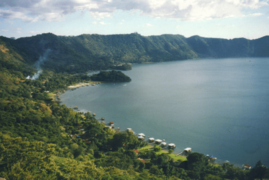
Lake Coatepeque (in Spanish, Lago de Coatepeque) is a large lake found inside the eastern part of the Coatepeque Caldera. It is located in the Coatepeque area of the Santa Ana region in El Salvador.
Features of Lake Coatepeque
- Hot Springs: You can find natural hot springs near the edges of the lake.
- Size: The lake covers about 26 square kilometers (10 square miles). This makes it one of the largest lakes in El Salvador.
- Isla Teopán: Inside the lake is an island called Teopan. This island was once an important place for the ancient Mayan people.
-
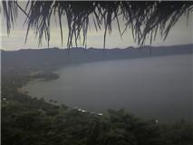
A view of the Coatepeque area.
-
A beautiful view of Lake Coatepeque.
-
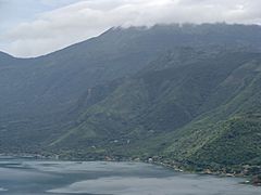
Clouds covering the Ilamatepec volcano, near the caldera.


See also
- List of volcanoes in El Salvador
 In Spanish: Lago de Coatepeque para niños
