Santa Cruz La Laguna facts for kids
Quick facts for kids
Santa Cruz La Laguna
|
|
|---|---|
|
Municipality and town
|
|

Santa Cruz La Laguna
|
|
| Country | |
| Department | |
| Area | |
| • Total | 12 km2 (5 sq mi) |
| Elevation | 1,665 m (5,463 ft) |
| Highest elevation | 2,520 m (8,270 ft) |
| Lowest elevation | 1,562 m (5,125 ft) |
| Population
(Census 2002)
|
|
| • Total | 4,192 |
| • Density | 350/km2 (900/sq mi) |
| Time zone | UTC-6 (Central Time) |
| Postal code |
07014
|
| Country calling code | 502 |
| Climate | Cwb |
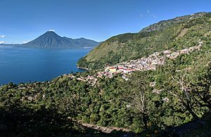
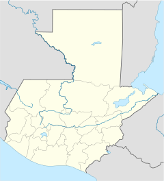
Santa Cruz La Laguna is a special town, also called a municipality, in Guatemala. It sits on the northern shore of a beautiful lake called Lago de Atitlán. This area is part of the Sololá department.
Santa Cruz La Laguna includes the main villages of Santa Cruz La Laguna and Tzununá. It also has four smaller villages. In 2018, about 9,392 people lived here. Most of the people are Kaq'chikel, who are native Maya people.
About Santa Cruz La Laguna Village
Santa Cruz La Laguna is a traditional Maya village. It is built on the steep side of the lake, about 325 feet (99 meters) above the water. Around 3,100 people live in this part of the municipality.
This village is quite unique because you can only reach it by boat or by walking. There is a single, winding path that goes from the boat dock up to the village. A very rough road connects Santa Cruz to the city of Sololá. This road is mainly used to bring in heavy items like building materials and furniture.
The village does not have many roads for cars. It also does not have a public telephone system or a main shopping area. However, the sports court is a popular place where children play basketball and soccer. Electricity is sometimes available but can be expensive. Because of this, not all homes have electricity.
Photos of Santa Cruz La Laguna
See also
 In Spanish: Santa Cruz La Laguna para niños
 | Shirley Ann Jackson |
 | Garett Morgan |
 | J. Ernest Wilkins Jr. |
 | Elijah McCoy |


