Santa Isabel, Utuado, Puerto Rico facts for kids
Quick facts for kids
Santa Isabel
|
|
|---|---|
|
Barrio
|
|

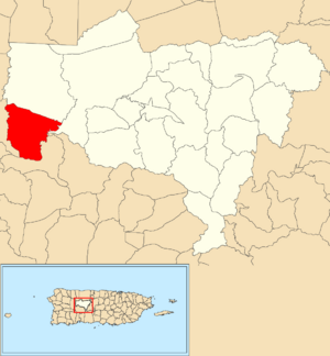
Location of Santa Isabel within the municipality of Utuado shown in red
|
|
| Commonwealth | |
| Municipality | |
| Area | |
| • Total | 5.35 sq mi (13.9 km2) |
| • Land | 5.35 sq mi (13.9 km2) |
| • Water | 0 sq mi (0 km2) |
| Elevation | 1,729 ft (527 m) |
| Population
(2010)
|
|
| • Total | 660 |
| • Density | 123.4/sq mi (47.6/km2) |
| Source: 2010 Census | |
| Time zone | UTC−4 (AST) |
Santa Isabel is a special kind of neighborhood called a barrio in Utuado, Puerto Rico. In 2010, about 660 people lived there.
Where is Santa Isabel?
Santa Isabel is a quiet barrio located high up in the mountains. It sits about 1,729 feet (527 meters) above sea level. This area is just south of another barrio called Ángeles, within the town of Utuado, Puerto Rico. The total size of Santa Isabel is about 5.35 square miles (13.86 square kilometers).
A Look at History
Puerto Rico became a territory of the United States after the Spanish–American War. This happened because of the Treaty of Paris of 1898. In 1899, the United States government counted everyone living in Puerto Rico. At that time, 875 people lived in the Santa Isabel barrio.
The number of people living in Santa Isabel has changed over the years:
| Historical population | |||
|---|---|---|---|
| Census | Pop. | %± | |
| 1900 | 875 | — | |
| 1980 | 756 | — | |
| 1990 | 840 | 11.1% | |
| 2000 | 682 | −18.8% | |
| 2010 | 660 | −3.2% | |
| U.S. Decennial Census 1899 (shown as 1900) 1910-1930 1930-1950 1980-2000 2010 |
|||
More to Explore
 In Spanish: Santa Isabel (Utuado) para niños
- List of communities in Puerto Rico


