
Santry River facts for kids
Quick facts for kids Santry River |
|
|---|---|

Santry River, Kilmore, Dublin 5
|
|
| Native name | Irish: Abhainn Sheantraibh |
| Physical characteristics | |
| Main source | Harristown and Dubber, County Dublin |
| River mouth | Dublin Bay (Raheny) |
| Basin features | |
| Tributaries |
|

The Santry River (also known as Irish: Abhainn na Culoige) is a small river located on the north side of Dublin city in Ireland. It used to be called Skillings Glas. This river is one of about 40 waterways that Dublin City Council keeps an eye on.
Contents
The River's Journey
,_mouth,_in_Kavanagh_JM_-_A_Grey_Day,_Watermill_Bridge_(1895).jpg)
The Santry River starts high up, about 80 meters above sea level. It begins in the countryside areas of Harristown and Dubber. These places are now managed by Fingal County Council, close to St. Margaret's village and Dublin Airport.
The main starting point of the river is at the end of a small path in what was once the Harristown Demesne. New roads have now cut this area off. The river then flows south of Dublin Airport. Some smaller streams from the airport join it here. It also flows near the new Dublin Bus depot in Harristown.
Upper Course and Quinn's River
Along with the Dubber branch, the river flows mostly in the open air during its upper journey. It goes through the Sillogue Public Golf Course. Then it continues through more of Ballymun. In this part, the main channel of the river is called Quinn's River.
Through Santry and Coolock
The river then flows through the area called Santry. Here, it is a big part of the Santry Demesne, which is now a public park. You can find small lakes within the park that are fed by the river.
In Coolock, the river creates a central valley that cuts through the district. It has a pond, sometimes called Coolock Lake, and a small waterfall. The river flows past the Stardust Memorial Park. It also goes through the grounds of Cadbury's Ireland. Here, there is a special station that monitors the river's health. There is also an old burial mound (tumulus) on its banks.
Reaching the Sea in Raheny
The Santry River enters Raheny near the start of Tonlegee Road. It flows next to the Edenmore lands and past St. Joseph's Hospital. It then goes through the center of Raheny village. It also flows alongside the grounds of Manor House School.
The river goes underground in two places, at the beginning and end of what was the Bettyglen Estate. Finally, it reaches the sea. Its mouth forms part of the eastern "lagoon" behind North Bull Island. The river's water then flows into Sutton Creek. This lower part of the river is sometimes called the "Raheny River."
Drainage Link to Naniken River
On the map sketch, you might see a dotted line. This line shows an artificial link. It was built by Dublin Corporation to connect the Santry River and the Naniken River. This link helps to control the water flow in both rivers. It also helps manage any flooding that might happen. This connection is located at the western end of Kilmore West in Coolock.
Nearby River Areas
In its upper parts, the Santry River's drainage area is next to other river basins. One is the Wad River basin, which reaches the sea near Clontarf. Another is the Mayne River system, which ends at Baldoyle Bay.
Closer to the city, the Naniken River basin is nearby. To the north and east, two smaller streams drain parts of Edenmore and Raheny. These are the Fox Stream, which reaches the sea at the end of Fox's Lane. The other is the Blackbanks Stream, which meets the sea where Howth Road and James Larkin Road come together.
Images for kids
-
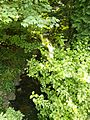
Santry River at Raheny village

