Naniken River facts for kids
Quick facts for kids Naniken River |
|
|---|---|

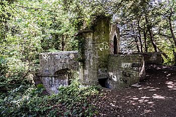
Folly bridge in St. Anne's Park
|
|
| Native name | Irish: An Nainicín |
| Physical characteristics | |
| Main source | Santry |
| River mouth | Dublin Bay, Raheny, by St Anne's Park |
The Naniken River (Irish: An Nainicín) is a small river located on the north side of Dublin city in Ireland. It's one of many waterways watched over by Dublin City Council.
This river is quite interesting because parts of it flow underground in pipes, which is called being "culverted." You can see the Naniken River openly flowing through St Anne's Park for its lower section. Even though it's a small river, it sometimes causes flooding in certain areas. The entire river flows within the area managed by Dublin City Council.
Contents
What's in a Name?
The name of the river, Naniken, is sometimes spelled as Nannikin or Naneken. We're not entirely sure where the name comes from. Some people think it might be a smaller version of the name of the Nanny River, which is a much bigger river flowing just north of Dublin.
Where the River Flows
The Naniken River has a journey that takes it through different parts of Dublin, sometimes above ground and sometimes hidden away.
Starting Point and Hidden Journey
The Naniken River begins its journey in Santry, under a road called Shanliss Way. This area is now a place with many light industrial businesses.
From there, the river flows underground, passing beneath Schoolhouse Lane and the Oak Park area. It even goes under the northern entrance of the Dublin Port Tunnel. The river then continues through areas like Beaumont and Artane. It passes under several roads, including Lorcan Crescent, Coolgariff Road, Kilmore Road, and Ardlea Road. In this area, another hidden stream joins the Naniken from the land where Beaumont Hospital now stands.
The river then continues its hidden path under Maryfield Crescent and Mornington Grove, near the Artane Roundabout. It crosses under the Malahide Road and flows through southern Artane and western Harmonstown. Finally, it reaches Raheny by going under the railway line through a special pipe called a siphon. After that, it flows under a former pathway near some early apartment buildings called Rosevale.
The part of the river from Harmonstown to St Anne's Park is sometimes known as the Ballyhoy River. There's even a road in the St. Anne's housing area named after it.
In Raheny, the Naniken River used to mark the edge of the church's land. The river goes under Howth Road at a place called Ballyhoy Bridge. After this, it finally comes out from its underground pipes and flows openly through St Anne's Park.
Through St Anne's Park to the Sea
The Naniken River is a very important part of St Anne's Park, which is Dublin's second-largest public park. This park used to be a big estate owned by the Guinness family.
The river flows in a shady channel through areas with playing fields. It then goes through the Dublin City Millennium Arboretum, which is a special collection of trees. In the middle of the park, the river flows through a more noticeable valley. In the 1800s, there was a pond with a small waterfall near the river, but it's not there anymore.
The Guinness family built some special features near the river, like decorative bridges. One tall bridge was removed in the 1980s because it wasn't safe. There were also places where you could cross the river, called fords, and some wider areas of the river.
Near the coast, a small channel branches off from the Naniken to supply water to the Duck Pond, also known as the Old Pond. The main river then flows around and under the James Larkin Road. It finally enters the western part of a "lagoon" (a shallow body of water) behind North Bull Island. This lagoon is also known as Crab Water or Raheny Lake. The line of the Naniken River from its mouth marks the border between the areas of Raheny and Clontarf. It also marks the beginning of the Raheny part of Bull Island.
Why Parts of the River are Hidden
Like many smaller rivers in Dublin, the upper and middle parts of the Naniken River were covered over time. This process is called "culverting." For example, covering the section from Coolgariff Road to Kilmore Road was even talked about in government meetings in 1960.
Connected to the Santry River
There's a special drainage connection between the Naniken River and the Santry River. This connection is located at the western end of Kilmore West. It helps to reduce the amount of water flowing from the Naniken's upper parts and also helps manage flooding or overflow situations.
Flooding Challenges
Even though the Naniken is a small river, it has been around for a long time and often causes flooding. This happens in many years, similar to the nearby Wad River. Some places that frequently experience flooding include Maryfield Crescent, Rosemount Avenue, and parts of Kilmore.
In 2014, the City Manager recognized the risk of flooding from the Naniken River. They noted that there wasn't enough money available right away for big repair projects. However, they agreed that the City Council would spend 60,000 euro to study the river's water flow and understand the flooding better.

