Sapelo River facts for kids
Quick facts for kids Sapelo River |
|
|---|---|

The Sapelo River in McIntosh County
|
|
| Country | United States |
| Physical characteristics | |
| Main source | Georgia |
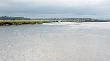
The Sapelo River is a cool waterway in McIntosh County, Georgia. It flows for about 23 miles (37 kilometers). This river is mostly affected by the ocean's tides, which means its water level changes with the high and low tides.
Contents
Exploring the Sapelo River
The Sapelo River is an important part of the natural environment in Georgia. It helps connect the land to the vast Atlantic Ocean. Understanding rivers like Sapelo helps us learn about our planet's water systems.
Where Does the River Start?
The Sapelo River begins its journey between two major roads. These are Interstate 95 and U.S. Route 17. It starts near a small community called Eulonia. From there, the river begins to flow towards the east.
Journey to the Atlantic Ocean
As the Sapelo River flows east, it winds its way through special areas. These areas are called salt marshes. Salt marshes are wetlands that are often flooded by ocean tides. They are home to many unique plants and animals.
After passing through these marshes, the river reaches Sapelo Sound. A "sound" is a wide channel of water that connects to the ocean. Sapelo Sound is like a big arm of the Atlantic Ocean.
Islands and Sounds Nearby
Sapelo Sound is an important body of water. It separates two interesting islands. To the north of the sound is St. Catherines Island. To the south is Sapelo Island. These islands are known for their natural beauty and history.
The river's journey from land to the ocean shows how different parts of nature are connected. It highlights the importance of rivers in shaping our landscapes.
 | James B. Knighten |
 | Azellia White |
 | Willa Brown |

