Sardis, Georgia facts for kids
Quick facts for kids
Sardis, Georgia
|
||
|---|---|---|
|
||

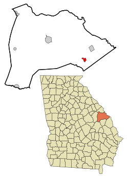
Location in Burke County and the state of Georgia
|
||
| Country | United States | |
| State | Georgia | |
| County | Burke | |
| Area | ||
| • Total | 1.56 sq mi (4.05 km2) | |
| • Land | 1.55 sq mi (4.01 km2) | |
| • Water | 0.01 sq mi (0.04 km2) | |
| Elevation | 240 ft (73 m) | |
| Population
(2020)
|
||
| • Total | 995 | |
| • Density | 642.76/sq mi (248.13/km2) | |
| Time zone | UTC-5 (Eastern (EST)) | |
| • Summer (DST) | UTC-4 (EDT) | |
| ZIP code |
30456
|
|
| Area code(s) | 478 | |
| FIPS code | 13-68740 | |
| GNIS feature ID | 0322525 | |
Sardis is a small city located in Burke County, Georgia, in the United States. In 2020, about 995 people lived there. It's part of the larger Augusta area, which is sometimes called the Central Savannah River Area (CSRA).
Contents
History of Sardis
Around the early 1900s, a small community started to grow in southeast Burke County. People called this crossroads area Frog Wallow.
How Sardis Got Its Name
A new railroad, the Savannah & Atlanta Railway, was built through the tiny town. In 1912, the Georgia Legislature officially made it a city and named it Sardis. The name came from a Baptist church that had been important in the town for many years. The church itself was named after Sardis, an ancient city in what is now Turkey.
Growth and Changes Over Time
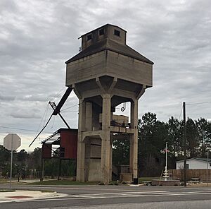
Sardis grew for several decades, especially with a busy lumber industry. But in 1962, the company that owned the railroad decided to stop using the tracks between Waynesboro and Sylvania. This change hurt the local economy. The tracks were taken away in 1964. Even today, Sardis still has its old train station and a tall structure called a coal tower.
Geography and Location
Sardis is in the southeastern part of Burke County. Its exact location is 32°58′28″N 81°45′31″W / 32.97444°N 81.75861°W. It is about 17 miles (27 km) southeast of Waynesboro, which is the main town of Burke County.
Land and Water Area
The United States Census Bureau says that the city covers a total area of about 1.56 square miles (4.0 square kilometers). Most of this area is land, about 1.55 square miles (4.01 square kilometers). A very small part, about 0.01 square miles (0.04 square kilometers), is water.
Population and People
| Historical population | |||
|---|---|---|---|
| Census | Pop. | %± | |
| 1930 | 580 | — | |
| 1940 | 667 | 15.0% | |
| 1950 | 695 | 4.2% | |
| 1960 | 829 | 19.3% | |
| 1970 | 643 | −22.4% | |
| 1980 | 1,180 | 83.5% | |
| 1990 | 1,116 | −5.4% | |
| 2000 | 1,171 | 4.9% | |
| 2010 | 999 | −14.7% | |
| 2020 | 995 | −0.4% | |
| U.S. Decennial Census 1850-1870 1870-1880 1890-1910 1920-1930 1940 1950 1960 1970 1980 1990 2000 2010 |
|||
The table above shows how the population of Sardis has changed over many years.
Who Lives in Sardis?
As of the 2020 United States census, there were 995 people living in Sardis. These people made up 328 households and 198 families.
| Race | Num. | Perc. |
|---|---|---|
| White (non-Hispanic) | 469 | 47.14% |
| Black or African American (non-Hispanic) | 436 | 43.82% |
| Native American | 3 | 0.3% |
| Asian | 1 | 0.1% |
| Other/Mixed | 74 | 7.44% |
| Hispanic or Latino | 12 | 1.21% |
See also
 In Spanish: Sardis (Georgia) para niños


