Sasser, Georgia facts for kids
Quick facts for kids
Sasser, Georgia
|
|
|---|---|

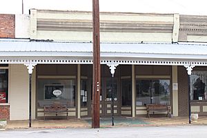
Sasser Town Hall in Sasser Commercial Historic District
|
|

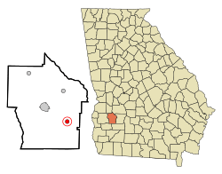
Location in Terrell County and the state of Georgia
|
|
| Country | United States |
| State | Georgia |
| County | Terrell |
| Area | |
| • Total | 0.78 sq mi (2.02 km2) |
| • Land | 0.78 sq mi (2.02 km2) |
| • Water | 0.00 sq mi (0.00 km2) |
| Elevation | 318 ft (97 m) |
| Population
(2020)
|
|
| • Total | 287 |
| • Density | 367.48/sq mi (141.90/km2) |
| Time zone | UTC-5 (Eastern (EST)) |
| • Summer (DST) | UTC-4 (EDT) |
| ZIP codes |
31785, 39885
|
| Area code(s) | 229 |
| FIPS code | 13-68796 |
| GNIS feature ID | 0332984 |
Sasser is a small town located in Terrell County, Georgia, in the United States. In 2020, about 287 people lived there. It is part of the larger Albany metropolitan area.
History of Sasser
The town of Sasser began with a post office in 1881. This was a place where people could send and receive mail. The name "Sasser" comes from a person named William Sasser.
Later, in 1890, the Georgia General Assembly officially made Sasser a town. This meant it had its own local government.
Geography of Sasser
Sasser is located in the southwestern part of Georgia. Its exact location is 31°43′12″N 84°20′52″W / 31.72000°N 84.34778°W. This helps people find it on a map.
The town covers a total area of about 2.02 square kilometers (0.78 square miles). All of this area is land. There are no large bodies of water within the town limits.
Population and People
| Historical population | |||
|---|---|---|---|
| Census | Pop. | %± | |
| 1900 | 322 | — | |
| 1910 | 441 | 37.0% | |
| 1920 | 402 | −8.8% | |
| 1930 | 412 | 2.5% | |
| 1940 | 365 | −11.4% | |
| 1950 | 371 | 1.6% | |
| 1960 | 382 | 3.0% | |
| 1970 | 339 | −11.3% | |
| 1980 | 407 | 20.1% | |
| 1990 | 335 | −17.7% | |
| 2000 | 393 | 17.3% | |
| 2010 | 279 | −29.0% | |
| 2020 | 287 | 2.9% | |
| U.S. Decennial Census 1850-1870 1870-1880 1890-1910 1920-1930 1940 1950 1960 1970 1980 1990 2000 2010 |
|||
The study of how many people live in a place is called demographics. In 2000, Sasser had 393 residents. These people lived in 152 households, with 112 of them being families.
By 2020, the population of Sasser had decreased to 287 people. The chart above shows how the population has changed over many years.
See also
 In Spanish: Sasser (Georgia) para niños
 | Janet Taylor Pickett |
 | Synthia Saint James |
 | Howardena Pindell |
 | Faith Ringgold |


