Saunders Island, South Sandwich Islands facts for kids
 |
|

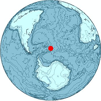
Location of Saunders Island
|
|
| Geography | |
|---|---|
| Coordinates | 57°48′S 26°29′W / 57.80°S 26.49°W |
| Archipelago | South Sandwich Islands |
| Highest elevation | 990 m (3,250 ft) |
| Highest point | Mount Michael |
| Administration | |
|
United Kingdom
|
|
| Demographics | |
| Population | Uninhabited |
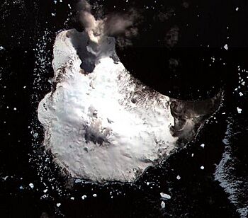
Saunders Island is a fascinating, crescent-shaped island located in the South Sandwich Islands. These islands are a British Overseas Territory far away in the southern Atlantic Ocean. It sits between Candlemas Island and Montagu Island.
Saunders Island is about 8.5 kilometers long and 5 kilometers wide. It is a volcanic island with an active volcano called Mount Michael. This mountain stands 990 meters tall. Mount Michael has a special lava lake inside its top crater. Hot gases often rise from the crater, and there is clear evidence of recent eruptions all over the island.
The island is a very important home for many bird species, especially penguins. However, not many plants grow here. You will mostly find lichens and some moss patches. Most of Saunders Island is covered in ice and snow.
Contents
Discovering Saunders Island
Saunders Island was first seen in 1775 by the famous explorer James Cook. He was sailing on his ship, the HMS Resolution. The island is part of the South Sandwich Islands, which are found in the southern Atlantic Ocean. They are at the eastern edge of the Scotia Sea.
Where is Saunders Island?
These islands are very remote, meaning they are far from other land. They are about 2000 kilometers north of Antarctica. They are also about the same distance southeast of the Falkland Islands. Because they are so remote, volcanic eruptions often happen without many people noticing. Bad weather and rough seas also make it hard to visit.
Politically, Saunders Island is part of the British Overseas Territory of South Georgia and the South Sandwich Islands. Sometimes, tourist boats visit the island. They can land on several beaches made of large rocks. People also fish in the waters around the island.
How the Islands Were Formed
The South Sandwich Islands were created by powerful forces deep within the Earth. The Atlantic Ocean floor is slowly sliding under another part of the Earth's crust. This process has been happening for millions of years. It has created a chain of volcanoes, which form the South Sandwich Islands.
This chain of volcanic islands stretches for about 350 kilometers. It includes islands like Zavodovski Island, Visokoi Island, Leskov Island, Candlemas Island, Montagu Island, Bristol Island, and Southern Thule. Saunders Island, Montagu Island, and Bristol Island are the largest. Most of these volcanoes are active, either letting out hot gases or having erupted in the past. The islands are made up of layers of hardened lava and volcanic ash.
A Closer Look at Saunders Island
Saunders Island has a unique crescent shape. It is about 8.5 kilometers long and 5 kilometers wide. On the eastern side, there is a wide bay called Cordelia Bay. This bay opens towards the northeast. It is bordered by rocky points like Nattriss Point and Sombre Point.
Features of the Island
About 80% of Saunders Island is covered by ice. You can see rocky areas along the coasts. There are also old, worn-down volcanic cones on the eastern side. The most important feature is the Mount Michael volcano.
Mount Michael is a steep, ice-covered volcano shaped like a cone. Its summit, or top, is usually said to be 990 meters high. It has a crater at its peak. This crater might be up to 700 meters wide. Around the summit crater, there is another, larger crater that is filled with ice. A glacier flows down the eastern side of Mount Michael, and the ice is full of deep cracks.
The Ashen Hills are on the southern part of the island. They are a group of old volcanic cones that overlap each other. These hills show signs of past powerful eruptions. Rivers have carved channels into the Ashen Hills, revealing layers of volcanic material.
Underwater Around Saunders Island
Saunders Island sits on a shallow underwater shelf. This shelf extends north to form Saunders Bank. There are also signs of underwater eruptions around the island. The ocean floor around Saunders Island has several underwater mountains, called seamounts. These include Minke Seamount, Orca Seamount, and Humpback Seamount to the north. To the southwest, there are Fin Seamount and Southern Right Seamount.
The rocks found on Saunders Island are mostly volcanic. They are formed from cooled lava.
Mount Michael: An Active Volcano
Mount Michael is an active volcano. Hot gases rise from its summit crater. Sometimes, it has small eruptions that throw rocks a few hundred meters away. These eruptions also spread volcanic ash on the eastern slopes. People have reported seeing steam coming from the summit crater since 1820. This steam often hides the top of the mountain.
Scientists use special tools to study the volcano from far away. They have found a lava lake inside Mount Michael's summit crater. This lake is about 0.01 square kilometers in size. Most of the lake's surface is covered by a cooler crust. However, the lava underneath is extremely hot, reaching temperatures between 989 and 1279 degrees Celsius. The size of this lava lake changes over time. The volcano also releases volcanic gases, like sulfur dioxide and carbon dioxide, into the air every day.
Life on Saunders Island
The South Sandwich Islands have a polar climate. This means it is very cold, especially on Saunders Island. Storms and snowfall happen often. From July to November, the sea around the island is usually covered in ice.
Plants on the Island
Not many plants can survive in this harsh climate. Lichens are very common. You can also find algae and moss growing in large patches, especially near penguin colonies. Overall, the island looks mostly barren, meaning it has very little plant life.
Amazing Wildlife: Birds and Seals
Saunders Island is a vital breeding ground for many types of birds. Large bird colonies can be found in the Ashen Hills and along the northern and western coasts.
Many different penguins live and reproduce here:
- Adelie penguins
- Chinstrap penguins (with over 100,000 breeding pairs!)
- Gentoo penguins
- Macaroni penguins
Other birds that breed on the island include:
- Black-bellied storm petrels
- Brown skuas
- Cape petrels
- Dominican gulls
- Snow petrels
- Southern fulmars
- Wilson's storm petrels
Some birds, like Antarctic terns, king penguins, and southern giant petrels, visit the island but do not seem to breed there.
Mammals also use Saunders Island for reproduction. Antarctic fur seals and southern elephant seals have their pups here. Weddell seals have been seen on the island, but they have not been observed reproducing. The penguin colonies are mostly found in areas along the coast that are free of ice, such as the Ashen Hills. Sometimes, volcanic activity has caused many penguins to die.
Protecting the Ocean Around the Island
To protect the amazing marine life, a marine protected area was created around the South Sandwich Islands in 2012. More areas were added in 2019. This helps keep the ocean healthy for all the creatures that live there.
Sometimes, trash from the ocean washes up on the beaches of Saunders Island. This includes natural items like driftwood and also man-made items.
See also
 In Spanish: Isla Saunders (Sandwich del Sur) para niños
- List of Antarctic and sub-Antarctic islands

