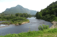
Sautauriski Mountain facts for kids
Quick facts for kids Sautauriski Mountain |
|
|---|---|
| Highest point | |
| Peak | 727 |
| Geography | |
| Country | Canada |
| State/Province | Quebec |
| Range coordinates | 47°12′29″N 71°22′55″W / 47.20805°N 71.38194°W |
| Parent range | Laurentian Mountains |
The Sautauriski Mountain is a cool peak in Jacques-Cartier National Park in Quebec, Canada. It used to be called "Mont des Loups," which means "Wolf Mountain." This mountain stands tall at 727 meters (about 2,385 feet) and is a popular spot for hikers. It's located near the town of Stoneham-et-Tewkesbury.
Where is Sautauriski Mountain?
Sautauriski Mountain is found in the southern part of Jacques-Cartier National Park. It's in the area called Stoneham-et-Tewkesbury, which is part of the La Jacques-Cartier Regional County Municipality. This whole region is in Capitale-Nationale, Quebec, Canada.
The top of the mountain is located:
- About 1 kilometer (0.6 miles) northeast of the Jacques-Cartier River.
- About 2.4 kilometers (1.5 miles) north of where the Sautauriski and Jacques-Cartier rivers meet.
- About 5.4 kilometers (3.4 miles) north of the center of Stoneham-et-Tewkesbury village.
The mountain sits between the Jacques-Cartier River on its southwest side and the Sautauriski River on its east side. It's easier to reach the top from the north. The east and southwest sides have very steep cliffs.
Hiking the Mountain Path
The "Les Loups" trail on Sautauriski Mountain is super popular with hikers in Jacques-Cartier National Park. It's a well-marked path that goes through the forest. This trail climbs about 452 meters (1,483 feet) from start to finish.
The first part of the climb is quite steep. About halfway up, you'll reach a lookout point at 574 meters (1,883 feet) high. From here, you get an amazing view of the tall cliffs along the Jacques-Cartier River.
The next part of the climb is easier and goes on for about 2.7 kilometers (1.7 miles). This leads you to a second viewpoint. After that, the path gets narrower and a bit rougher as it follows the mountain's sides.
At the very top, which is 727 meters (2,385 feet) high, hikers can see incredible views. You'll see the Laurentian Mountains and the valleys of the Jacques-Cartier and Sautauriski rivers.
During weekends in September, up until Thanksgiving, the trail gets very busy. This is because the leaves on the trees turn beautiful autumn colors. If you visit during this busy time, you'll need to use a shuttle bus. This shuttle takes you from the Park Discovery and Access Center to the start of the trail. The entrance to Parc national de la Jacques-Cartier is at 103 chemin du Parc-National, in Stoneham-et-Tewkesbury, just north of Québec.
What's in a Name?
The name "Sautauriski Mountain" is connected to the name of the Sautauriski River.
The official name "Montagne de la Sautauriski" was made official on August 2, 1974. This was done by the Commission de toponymie du Québec, which is like a special group that names places in Quebec.
Related articles
- La Jacques-Cartier Regional County Municipality
- Stoneham-et-Tewkesbury, a municipality
- Jacques-Cartier National Park
- Laurentides Wildlife Reserve
- Sautauriski River
- Jacques-Cartier River
- Lac Jacques-Cartier Massif


