
Jacques-Cartier River facts for kids
Quick facts for kids Jacques-Cartier River |
|
|---|---|

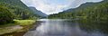
The Jacques-Cartier River in the Jacques-Cartier National Park
|
|
| Other name(s) | Rivière Jacques-Cartier |
| Country | Canada |
| Province | Quebec |
| Region | Capitale-Nationale |
| Physical characteristics | |
| Main source | Nadreau Lake Lac-Jacques-Cartier 842 m (2,762 ft) 47°35′35″N 71°04′52″E / 47.593115°N 71.081103°E |
| River mouth | Saint Lawrence River Donnacona 4 m (13 ft) 46°40′17″N 71°44′50″W / 46.67139°N 71.74722°W |
| Length | 161 km (100 mi) |
| Basin features | |
| Basin size | 2,515 km2 (971 sq mi) |
| Tributaries |
|
The Jacques-Cartier River is a beautiful river in Quebec, Canada. It stretches for about 161 kilometers (100 miles). The river starts at Jacques-Cartier Lake in the Laurentides Wildlife Reserve. It then flows south and empties into the Saint Lawrence River near Donnacona. This spot is about 30 kilometers (19 miles) upstream from Quebec City.
The Jacques-Cartier River is being considered for a special title: a Canadian Heritage River. This means it's recognized for its natural, cultural, and recreational value.
People use the area around the river for different things. The most important activity is forestry, which means cutting down trees for wood. After that, tourism and outdoor fun are popular. Closer to the river's end, some people also farm the land.
During winter, the river's surface usually freezes. This happens from early December to late March. However, it's generally safe to walk or play on the ice from late December to early March.
Contents
Where is the Jacques-Cartier River Located?
The Jacques-Cartier River basin covers a large area of about 2,515 square kilometers (971 square miles). Most of the river, about 160 kilometers (99 miles), flows through the Laurentian Mountains. These mountains are part of the Canadian Shield, which is a very old geological area. The river then travels about 17 kilometers (11 miles) through the St. Lawrence Lowlands. This flatter area starts near Pont-Rouge and goes all the way to where the river meets the Saint Lawrence.
Most of the land around the river is wild or protected. This is especially true near its source. About 77% of the river's length is protected by the Laurentides Wildlife Reserve and the Jacques-Cartier National Park. In the park, you can see a deep valley shaped by glaciers during the last ice age. Even so, about 25,000 people live near the river's mouth. The river flows through several towns like Tewkesbury, Saint-Gabriel-de-Valcartier, Shannon, Sainte-Catherine-de-la-Jacques-Cartier, Pont-Rouge, and Donnacona.
Main Rivers Joining the Jacques-Cartier
Several important rivers flow into the Jacques-Cartier River. These are called tributaries. Some of them include:
- Rivière aux Pommes (Apple River)
- Sautauriski River
- Ontaritzi River
- Rivière à l'Épaule (Shoulder River)
- Cachée River (Jacques-Cartier River tributary) (Hidden River)
- Launière River
- Rivière Jacques-Cartier Nord-Ouest
The Journey of the Jacques-Cartier River
The Jacques-Cartier River begins at Nadreau Lake, which is about 842 meters (2,762 feet) above sea level. This lake gets water from two smaller lakes, Plamondon Lake and another unnamed lake. From Nadreau Lake, the river flows for about 110 kilometers (68 miles), dropping 858 meters (2,815 feet) in height.
Upper Part of the River
The first part of the Jacques-Cartier River is about 27.6 kilometers (17.1 miles) long. It flows northwest towards Jacques-Cartier Lake. Along this path, the river passes through smaller lakes like Grandpré Lake and Petit Pré Lake. It also receives water from other lakes like Currier Lake, Fantôme Lake, and Nissard Lake. Finally, it reaches Jacques-Cartier Lake, which is a major body of water for the river. The river then flows south through this lake for about 10.6 kilometers (6.6 miles).
Middle Part of the River (After Jacques-Cartier Lake)
After leaving Jacques-Cartier Lake, the river continues south for about 22.3 kilometers (13.9 miles). It makes a turn to the west and goes through Lac Sept Îles, Lac Noir, and Lac Lafontaine. Further on, it meets the Launière River coming from the north. The river then flows south through a deep valley. It also meets the rivière Jacques-Cartier Nord-Ouest coming from the west.
Middle Part of the River (After Jacques-Cartier North-West River)
This section is about 38.8 kilometers (24.1 miles) long. The river flows south and collects water from the Cook River. It then turns southeast and meets the Sautauriski River from the east. Next, it flows south and meets the Cachée River (Jacques-Cartier River tributary) from the east. The river then makes some big curves, flowing south and southwest, until it meets the Cassian River from the west. Finally, it flows southeast, making a loop, until it reaches the bridge in the village of Valcartier.
Lower Part of the River (After Valcartier)
The last part of the Jacques-Cartier River is about 21.4 kilometers (13.3 miles) long. It flows south and southwest, passing under the bridge in Sainte-Catherine-de-la-Jacques-Cartier. It then flows south through farmland, making a turn to the east, until it reaches the railway bridge in Pont-Rouge. The river continues south, making two loops through farms and forests, until it goes under the Autoroute 40 bridge. Finally, it flows south, making one last loop, before reaching its mouth at the Saint Lawrence River.
Areas Prone to Flooding
Some parts of the Jacques-Cartier River can experience flooding. These areas are mainly in the towns of Sainte-Catherine-de-la Jacques-Cartier, Shannon, Saint-Gabriel-de-Valcartier, Stoneham-et-Tewkesbury, Donnacona (especially the Parc familial des Berges, south of route 138), and Pont-Rouge (upstream from rue Dupont, east of boulevard NotreDame, and on rue Auclair, in the Grand Remous area).
A Look Back: The History of the Jacques-Cartier River

The Hurons, a First Nation group, called the river Lahdaweoole in 1829. This name means "coming from far." Both the Hurons and the Montagnais people used the riverbanks for fishing and trapping. It's believed that Indigenous peoples have used this region for over 7,000 years!
In 1632, explorer Samuel de Champlain mentioned this river. He called it the "Sturgeon and Salmon River." Later, in 1656, a map showed it as "R. J. Quartier." This name likely came from the popular belief that Jacques Cartier had visited the river's mouth. The river was like a natural highway. Jesuit missionaries used it in the 1600s to reach the Lac Saint-Jean area.
In the late 1700s, logging became a big business in the Laurentian highlands. The Jacques-Cartier River was used to float logs downstream to the Saint Lawrence River and to sawmills. This practice of "log drives" continued until 1975. As French immigrants settled near the river's mouth, new towns and industries grew. For example, flour mills were built.
In 1895, the Laurentian Wildlife Reserve was created. This was to provide places for people to fish, hunt, and enjoy nature. After 1918, more and more fishing camps were built, making fishing very popular. The end of the First World War and new roads to Lac Saint-Jean also helped this popularity grow.
Later, hydro-electric dams were built on the river to create electricity. This continued until the 1970s. In 1972, there was a plan to flood the Jacques-Cartier River valley for a new power project. However, many people strongly opposed this idea. The government listened to the people and changed its decision. In 1981, the Jacques-Cartier National Park was created from part of the wildlife reserve. This park is about 671 square kilometers (259 square miles). It's a place where people can learn about nature and enjoy outdoor activities that protect the environment.
Plants and Animals: Life in the Jacques-Cartier Valley
The areas right along the river usually have a mixed forest. Here, you can find trees like yellow birch and sugar maple. However, the areas further away have a boreal forest, which is full of conifer trees, especially black spruce. This difference is clear in the steep parts of the valley, where the weather is a bit milder.
The animals living here are typical of a Canadian mixed forest. In the Jacques-Cartier River valley, you might spot 23 different kinds of mammals. These include the American black bear, bobcat, raccoon, gray wolf, river otter, porcupine, moose, white-tailed deer, and caribou.
There are also 104 types of birds. Some birds of prey you might see are the barred owl, American kestrel, and osprey. The river is home to 16 kinds of fish, with brook trout being very common. Sadly, Atlantic salmon disappeared from the river in the 1800s. But now, there's a program to bring them back!
Images for kids
-
A wide view of the Jacques-Cartier River.
