
Schröcken facts for kids
Quick facts for kids
Schröcken
|
||
|---|---|---|
 |
||
|
||

Location in the district
|
||

Schröcken
Location in Austria
|
||
| Country | Austria | |
| State | Vorarlberg | |
| District | Bregenz | |
| Area | ||
| • Total | 23.43 km2 (9.05 sq mi) | |
| Elevation | 1,269 m (4,163 ft) | |
| Time zone | UTC+1 (CET) | |
| • Summer (DST) | UTC+2 (CEST) | |
| Postal code |
6888
|
|
| Area code | 05519 | |
| Vehicle registration | B | |
| Website | www.warth-schroecken.com | |

Schröcken is a small town located in the Bregenz District in Vorarlberg, which is the westernmost state of Austria. It is a beautiful place nestled in the mountains.
Contents
Geography of Schröcken
Schröcken is found high up in the Austrian Alps. It sits at an elevation of 1,269 meters (about 4,163 feet) above sea level. A little over 12% of the area is covered by forests. Almost 40% of the land is made up of high Alpine areas, perfect for mountain activities.
History of Schröcken
Early Settlers and Name Changes
The area around Schröcken was first settled around the year 1300. The first people to live here were German-speaking groups called the Walser. They traveled to Austria from the Bernese Oberland in Switzerland.
The town was originally known as "Girsboden." The name "Schröcken" first appeared in the early 1600s.
Changes in Control
In 1806, Schröcken became part of a larger administrative area called Tannberg. For a few years, from 1805 to 1814, the town was controlled by the Free State of Bavaria. After that, it became part of the Austro-Hungarian Habsburg Empire.
In 1861, Schröcken joined the newly formed state of Vorarlberg, Austria. After World War II, from 1945 to 1955, Schröcken was part of the French occupation zone in Austria.
Population of Schröcken
The number of people living in Schröcken has changed over many years.
| Historical population | ||
|---|---|---|
| Year | Pop. | ±% |
| 1869 | 170 | — |
| 1880 | 177 | +4.1% |
| 1890 | 142 | −19.8% |
| 1900 | 133 | −6.3% |
| 1910 | 149 | +12.0% |
| 1923 | 130 | −12.8% |
| 1934 | 164 | +26.2% |
| 1939 | 250 | +52.4% |
| 1951 | 207 | −17.2% |
| 1961 | 196 | −5.3% |
| 1971 | 220 | +12.2% |
| 1981 | 214 | −2.7% |
| 1991 | 239 | +11.7% |
| 2001 | 233 | −2.5% |
| 2011 | 229 | −1.7% |
Places to See in Schröcken
Church of Our Lady of the Assumption
The very first church in Schröcken was built in 1639. More people joined the church between 1726 and 1732. Sadly, the building was destroyed by a fire in 1863.
People worked hard to rebuild it from 1864 to 1867. The church was then opened again for services. It is surrounded by a cemetery with a wall around it.
Chapel of the Annunciation
This chapel was built in the 18th century. It has a style called neo-Gothic. It was officially opened in 1779.
Economy of Schröcken
The main way people in Schröcken make a living is through tourism. Many visitors come to enjoy outdoor activities. These include skiing in winter and hiking and other mountain sports in the warmer months.
Transportation in Schröcken
Schröcken has public transportation. Buses, like Wälderbus 40 or 42, connect the town to the wider Vorarlberg and Austrian transport networks. The main road that goes through the area is called the Bregenzerwald Bundesstraße 200.
Education in Schröcken
The town has a primary school for younger students. There is also a kindergarten for very young children.
Climate in Schröcken
Schröcken experiences a mountain climate. The weather can change quite a bit between seasons. Winters are cold with lots of snow, and summers are mild.
| Climate data for Schröcken (1981–2010) | |||||||||||||
|---|---|---|---|---|---|---|---|---|---|---|---|---|---|
| Month | Jan | Feb | Mar | Apr | May | Jun | Jul | Aug | Sep | Oct | Nov | Dec | Year |
| Record high °C (°F) | 14.0 (57.2) |
15.5 (59.9) |
18.0 (64.4) |
21.0 (69.8) |
27.5 (81.5) |
30.0 (86.0) |
31.5 (88.7) |
29.6 (85.3) |
27.5 (81.5) |
24.4 (75.9) |
20.0 (68.0) |
20.0 (68.0) |
31.5 (88.7) |
| Mean daily maximum °C (°F) | 2.5 (36.5) |
2.8 (37.0) |
5.5 (41.9) |
9.1 (48.4) |
14.4 (57.9) |
17.3 (63.1) |
19.6 (67.3) |
19.1 (66.4) |
15.7 (60.3) |
12.2 (54.0) |
6.1 (43.0) |
2.9 (37.2) |
10.6 (51.1) |
| Daily mean °C (°F) | −2.1 (28.2) |
−2.0 (28.4) |
0.6 (33.1) |
4.1 (39.4) |
9.2 (48.6) |
12.2 (54.0) |
14.4 (57.9) |
13.8 (56.8) |
10.4 (50.7) |
7.1 (44.8) |
1.6 (34.9) |
−1.1 (30.0) |
5.7 (42.3) |
| Mean daily minimum °C (°F) | −5.4 (22.3) |
−5.4 (22.3) |
−2.7 (27.1) |
0.7 (33.3) |
5.2 (41.4) |
8.0 (46.4) |
10.4 (50.7) |
10.1 (50.2) |
7.1 (44.8) |
3.9 (39.0) |
−1.3 (29.7) |
−4.1 (24.6) |
2.2 (36.0) |
| Record low °C (°F) | −26.5 (−15.7) |
−24.0 (−11.2) |
−18.0 (−0.4) |
−11.3 (11.7) |
−4.5 (23.9) |
−2.0 (28.4) |
−0.2 (31.6) |
0.0 (32.0) |
−1.5 (29.3) |
−10.0 (14.0) |
−17.0 (1.4) |
−21.0 (−5.8) |
−26.5 (−15.7) |
| Average precipitation mm (inches) | 162 (6.4) |
156 (6.1) |
192 (7.6) |
140 (5.5) |
179 (7.0) |
229 (9.0) |
268 (10.6) |
256 (10.1) |
184 (7.2) |
130 (5.1) |
157 (6.2) |
171 (6.7) |
2,224 (87.6) |
| Average relative humidity (%) (at 14:00) | 60.4 | 59.1 | 57.2 | 52.6 | 53.2 | 58.2 | 57.6 | 60.2 | 60.6 | 60.4 | 65.5 | 66.2 | 59.3 |
| Source: Central Institute for Meteorology and Geodynamics | |||||||||||||
| Climate data for Schröcken (1971–2000) | |||||||||||||
|---|---|---|---|---|---|---|---|---|---|---|---|---|---|
| Month | Jan | Feb | Mar | Apr | May | Jun | Jul | Aug | Sep | Oct | Nov | Dec | Year |
| Record high °C (°F) | 14.0 (57.2) |
15.5 (59.9) |
18.0 (64.4) |
23.0 (73.4) |
26.0 (78.8) |
28.0 (82.4) |
31.5 (88.7) |
29.5 (85.1) |
29.2 (84.6) |
23.0 (73.4) |
20.0 (68.0) |
18.5 (65.3) |
31.5 (88.7) |
| Mean daily maximum °C (°F) | 2.6 (36.7) |
3.0 (37.4) |
5.3 (41.5) |
7.9 (46.2) |
13.6 (56.5) |
16.4 (61.5) |
18.8 (65.8) |
18.8 (65.8) |
15.6 (60.1) |
11.6 (52.9) |
5.7 (42.3) |
3.3 (37.9) |
10.2 (50.4) |
| Daily mean °C (°F) | −1.8 (28.8) |
−1.7 (28.9) |
0.5 (32.9) |
3.2 (37.8) |
8.4 (47.1) |
11.2 (52.2) |
13.5 (56.3) |
13.4 (56.1) |
10.2 (50.4) |
6.6 (43.9) |
1.3 (34.3) |
−0.7 (30.7) |
5.3 (41.5) |
| Mean daily minimum °C (°F) | −5.2 (22.6) |
−5.0 (23.0) |
−2.8 (27.0) |
−0.1 (31.8) |
4.6 (40.3) |
7.2 (45.0) |
9.6 (49.3) |
9.7 (49.5) |
6.8 (44.2) |
3.5 (38.3) |
−1.8 (28.8) |
−4.0 (24.8) |
1.9 (35.4) |
| Record low °C (°F) | −26.5 (−15.7) |
−24.0 (−11.2) |
−23.5 (−10.3) |
−11.5 (11.3) |
−7.8 (18.0) |
−1.0 (30.2) |
−0.2 (31.6) |
0.0 (32.0) |
−1.5 (29.3) |
−11.0 (12.2) |
−17.0 (1.4) |
−21.6 (−6.9) |
−26.5 (−15.7) |
| Average precipitation mm (inches) | 174.4 (6.87) |
161.8 (6.37) |
180.0 (7.09) |
162.3 (6.39) |
172.4 (6.79) |
252.1 (9.93) |
286.5 (11.28) |
233.7 (9.20) |
183.0 (7.20) |
138.3 (5.44) |
178.5 (7.03) |
185.8 (7.31) |
2,308.8 (90.90) |
| Average snowfall cm (inches) | 170.7 (67.2) |
156.8 (61.7) |
179.8 (70.8) |
91.5 (36.0) |
20.5 (8.1) |
4.3 (1.7) |
0.0 (0.0) |
0.5 (0.2) |
2.4 (0.9) |
16.9 (6.7) |
97.5 (38.4) |
175.1 (68.9) |
916.0 (360.6) |
| Average precipitation days (≥ 1.0 mm) | 12.7 | 11.7 | 14.3 | 14.7 | 16.2 | 18.0 | 17.2 | 16.3 | 12.8 | 11.5 | 12.8 | 13.3 | 171.5 |
| Average relative humidity (%) (at 14:00) | 59.9 | 57.6 | 56.0 | 53.4 | 52.1 | 57.6 | 56.9 | 58.6 | 58.7 | 58.9 | 65.8 | 63.4 | 58.2 |
| Source: Central Institute for Meteorology and Geodynamics | |||||||||||||
Images for kids
-
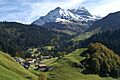
A view of Schröcken.
See also
 In Spanish: Schröcken para niños
