Schwarzheide facts for kids
Quick facts for kids
Schwarzheide
Carny Gózd |
||
|---|---|---|
 |
||
|
||
| Country | Germany | |
| State | Brandenburg | |
| District | Oberspreewald-Lausitz | |
| Elevation | 99 m (325 ft) | |
| Population
(2022-12-31)
|
||
| • Total | 5,681 | |
| Time zone | CET/CEST (UTC+1/+2) | |
| Postal codes |
01987
|
|
| Dialling codes | 035752 | |
| Vehicle registration | OSL (until 1994 SFB) | |
| Website | www.schwarzheide.de | |
Schwarzheide (also known as Carny Gózd in Sorbian) is a town in Germany. It is located in the Brandenburg state, in a region called Lower Lusatia. The town is built along the Schwarze Elster river. It's about 11 kilometers (7 miles) southwest of Senftenberg. The big cities of Berlin and Dresden are also nearby. A smaller river, the Pössnitz, flows through the eastern part of Schwarzheide.
Contents
What's Around Schwarzheide?
Schwarzheide has several towns as its close neighbors. To the south, you'll find Ruhland. To the west is Lauchhammer, and to the north is Schipkau. East of Schwarzheide is Senftenberg, which includes the district of Brieske.
Parts of Schwarzheide
Schwarzheide is made up of different areas, called districts:
- Schwarzheide-West (which used to be called Zschornegosda)
- Wandelhof
- Schwarzheide-Mitte
- Schwarzheide-Ost (this part includes Victoria and Naundorf)
A Look at Schwarzheide's History
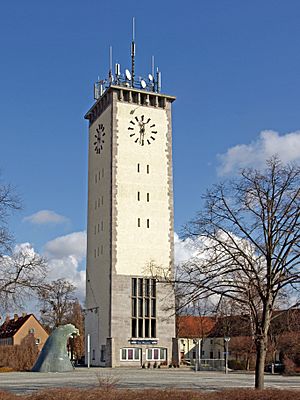
The most famous building in Schwarzheide is its old water tower. The town we know today, Schwarzheide, was formed on October 1, 1936. It was created by joining two older, separate villages: Zschornegosda (now Schwarzheide-West) and Naundorf (now part of Schwarzheide-Ost). The name "Schwarzheide" comes from the Sorbian name "Zschornegosda," which means "black heath" or "black wood."
We don't know exactly when these villages were first started. But Zschornegosda and Naundorf likely began in the 12th or 13th century. This was after the Sorbian people in the area became Christian.
The first time Naundorf was mentioned in writing was in 1421. Zschornegosda appeared in records in 1449. Naundorf was a typical "street village," meaning its houses were built along a main road. Zschornegosda was a "rotunde" or "okolnica," which is a village built in a circle. Its small chapel was on the highest sandy hill.
For a long time, wars, fires, and diseases slowed down the growth of both villages. Until the 18th century, neither village had more than 100 people.
Around 1780, something big happened: lignite coal was found west of Zschornegosda. This led to coal mining and the building of factories that made briquettes (like Ferdinand, Victoria, and Victoria II). The Schwarze Elster river was changed into a canal, which meant people could no longer make a living from fishing. In 1936, the major highway A13 was built, connecting the area to other cities.
Schwarzheide During World War II
In 1937, a large factory called Brabag II was finished in the area. This factory made gasoline and diesel fuel from lignite coal. During World War II, this plant was an important target. It also used people who were forced to work there. After the war, the factory became a state-owned company in East Germany.
The village grew a lot, and when its population reached 8,000 people, it officially became a town on January 11, 1967.
After 1990, the factory became part of a big company called BASF. Today, BASF Schwarzheide makes things like polyurethane.
How Schwarzheide is Governed
The town of Schwarzheide has a town parliament. This group includes the mayor and 18 other members who help make decisions for the town.
Town Partnerships
Schwarzheide has special partnerships with other towns in different countries. These partnerships help people from different places learn about each other's cultures.
- Krosno Odrzańskie in Poland
- Karcag in Hungary
- Piano di Sorrento in Italy
Population Growth in Schwarzheide
The number of people living in Schwarzheide has changed over many years.
| Schwarzheide: Population development within the current boundaries (2020) |
||||||||||||||||||||||||||||||||||||||||||||||||||||||||||||||||||||||||||
|---|---|---|---|---|---|---|---|---|---|---|---|---|---|---|---|---|---|---|---|---|---|---|---|---|---|---|---|---|---|---|---|---|---|---|---|---|---|---|---|---|---|---|---|---|---|---|---|---|---|---|---|---|---|---|---|---|---|---|---|---|---|---|---|---|---|---|---|---|---|---|---|---|---|---|
|
|
|
||||||||||||||||||||||||||||||||||||||||||||||||||||||||||||||||||||||||
Culture and Fun in Schwarzheide
Schwarzheide has some interesting places to visit. The 36-meter (118-foot) tall water tower, built in 1943-44, is a town symbol. The Lutherkirche, built in 1754, is also in the town center. For entertainment, the Freizeitpark Wandelhof is one of the oldest nightclubs in eastern Germany. There's also a cinema with four screens and space for 650 people.
Museums to Explore
- The Kulturhaus of BASF (on Schipkauer Straße)
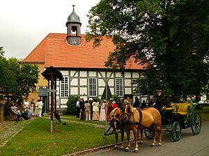
- The Museum of Schwarzheide (on Dorfaue)
Important Buildings
- The Evangelical church (built in 1953, it was the first new church in East Germany)
- The Lutheran church (Schwarzheide)
- The Evangelical chapel (on Parkstraße)
- The Catholic Holy Cross church (on Otto-Nuschke-Straße)
Nature and Outdoor Activities
Schwarzheide is surrounded by beautiful nature. You can find pine forests, lakes, meadows, and pastures. The Lusatian Lake District and Spreewald areas, known for their natural beauty, are also close by.
Sports and Recreation
If you like sports, the Eurospeedway Lausitz is located nearby. This is a famous race track.
How Schwarzheide Works
Getting Around Schwarzheide
Schwarzheide is well-connected by roads. The federal highway A13 (also known as E55) runs from Berlin to Dresden and has exits for Schwarzheide and Ruhland. The B169 road is also in the south. There is a train station in Schwarzheide-Ost.
Roads
- A 13 (E 55): This major highway connects Berlin and Dresden. You can get off at exit 16 (Schwarzheide) or exit 17 (Ruhland).
Trains
- RE 18: This train line connects Falkenberg (Elster) to Cottbus, stopping at places like Ruhland and Schwarzheide-Ost.
Major Companies in Town
The biggest employer in Schwarzheide is BASF Schwarzheide GmbH. This company is even building a new factory to make parts for batteries. Other important companies include Fränkische Rohrwerke and PeinigerRöRo.
Local Media
Schwarzheide has its own local radio station, called Schwarzheide & Ruhland.
Education in Schwarzheide
Schwarzheide has several schools for students of different ages.
- A secondary school (Schwarzheide-Wandelhof)
- A high school named after Hermann Emil Fischer
- A part of the Oberstufenzentrums Lausitz (OSZ) that trains people to be laboratory technicians and chemists
- A music school
Important People from Schwarzheide
Some people have been specially honored by the town:
- 2002: Hans-Herman Dehmel (He was the chief executive officer of BASF Schwarzheide from 1990 to 1995.)
- 2004: Sokratis Giapapas (He was the chief of Fränkisch Rohrwerke in Schwarzheide.)
 | Roy Wilkins |
 | John Lewis |
 | Linda Carol Brown |


