
Isles of Scilly facts for kids

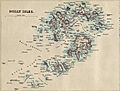
Map of the Isles of Scilly.
|
|
 Location in relation to Cornwall |
|
| Geography | |
|---|---|
| Location | Atlantic Ocean, 45 km (28 mi) off the coast of Cornwall, England |
| Coordinates | 49°56′10″N 6°19′22″W / 49.93611°N 6.32278°W |
| Administration | |
|
United Kingdom
|
|
| Demographics | |
| Population | (Ranked ) |


The Isles of Scilly are a group of islands. They are located off the southwestern tip of Cornwall, which is a part of Great Britain. An archipelago is a group of islands.
These islands have their own special local government. It is called a unitary authority council. This council has been in charge since 1890. Even though they are separate from Cornwall's main council, some services are shared. The islands are still part of the ceremonial county of Cornwall.
The Isles of Scilly are known for their amazing natural beauty. They are called an 'Area of Outstanding Natural Beauty'. However, the seas around them can be dangerous for ships. More than 530 shipwrecks have been found near the islands.
Contents
Discovering Ancient Scilly
The Isles of Scilly have been home to people for a very long time. People lived here since the Neolithic period. This was a time when early humans started farming. For many years, people on the islands lived by getting food from the land and sea. This is called subsistence living.
Even today, farming and fishing are important. But now, the main way people make a living is through tourism. Many visitors come to see the islands.
How the Islands Changed Over Time
Scientists believe the Isles of Scilly were once much larger. Many of the islands might have been joined together. This large island was possibly called Ennor. Around 400–500 AD, sea levels rose. This flooded the flat middle part of the land. That is how the islands we see today were formed.
There is proof that the islands were once bigger:
- Ancient Roman writings describe Scilly as "Scillonia insula." This means "Scilly island" (singular). It suggests there was one main island or a much larger one.
- Old farm remains have been found on Nornour. This is now a tiny rocky island. It is far too small for farming today.
- At very low tides, you can sometimes walk between some islands. This might be why there are old stories about lands that sank into the sea. One such story is about Lyonesse.
- You can see ancient field walls under the water near some islands. For example, off the island of Samson.
- Some old Cornish language place names also seem to describe past shorelines. They hint at land areas that are now underwater.
- The whole southern part of England has been slowly sinking. This is happening as Scotland rises after the Ice age.
The Mythical Land of Lyonesse
Between Land's End and the Isles of Scilly, there is a legendary lost land. It is called Lyonesse. This place is mentioned in stories about King Arthur.
Scilly was also a place of exile for two religious leaders. Instantius and Tiberianus were bishops in the 4th century. They were sent here because of their different beliefs.
Exploring Scilly's Geography
The Isles of Scilly are a group of five islands where people live. There are also about 140 other small rocky islands. They are located about 45 kilometers (28 miles) off Land's End. All the islands are made of a type of rock called granite.
Weather and Plant Life
The location of the islands creates interesting weather. The sea keeps the islands warm. This means they rarely get frost or snow. Because of this, local farmers can grow flowers earlier than on mainland Britain. The main farm product is cut flowers, especially daffodils.
However, the islands also face strong winds from the Atlantic Ocean. Powerful winter storms hit the islands often. You can see this in the landscape. On Tresco, the beautiful Tresco Abbey Gardens are on the island's southern end. They are full of lush, warm-weather plants. But the northern end of the island is windy. It has low heather plants and bare rock.
Images for kids
-
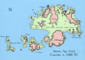
Projected coastline of the Isles of Scilly in 3,000 BCE, as supported by Barnett et al.
-
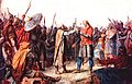
Olaf Tryggvason, who visited the islands in 986. It is said an encounter with a cleric there led him to Christianise Norway.
-
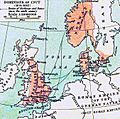
At the time of King Cnut, the Isles of Scilly fell outside England's rule, as did Cornwall and Wales.
-
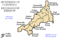
Scilly was one of the Hundreds of Cornwall (formerly known as Cornish Shires) in the early 19th century.
-
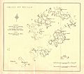
Scilly Isles: map by John Bartholomew (1874)
-
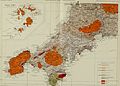
Map of Ancient Monuments on the Isles of Scilly
-
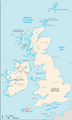
Location of the Isles of Scilly (circled)
-
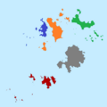
The five wards (which are also the civil parishes) of the Isles of Scilly; red is St Agnes, blue is Bryher, orange is Tresco, green is St Martin's, and grey is St Mary's.
-
Geological map of western Cornwall, with the Isles of Scilly (inset)
-
Five Islands Academy site at St Mary's
-
The Daymark (daylight version of a lighthouse) on St Martins, the nearest point to the mainland of Cornwall.
-

An electric golf buggy on St Mary's; these are road licensed and available for hire, as are bicycles, for use on public roads on the island.
-
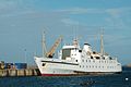
Scillonian III in St Mary's Harbour
-
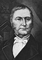
Augustus John Smith 1804–1872


_(14754540266).jpg)


.jpg)
See also
 In Spanish: Islas Sorlingas para niños
