
Sewell Branch (Andover Branch tributary) facts for kids
Quick facts for kids Sewell Branch |
|
|---|---|

Sewell Branch at Delaware-Maryland Stateline
|
|


|
|
| Other name(s) | Tributary to Andover Branch |
| Country | United States |
| State | Maryland Delaware |
| County | Kent (MD) Queen Annes (MD) Kent (DE) |
| Physical characteristics | |
| Main source | Pinks Branch divide Underwood Corner, Delaware 70 ft (21 m) 39°14′28″N 075°40′51″W / 39.24111°N 75.68083°W |
| River mouth | Andover Branch about 1 mile southeast of Peacock Corners, Maryland 20 ft (6.1 m) 39°14′30″N 075°47′43″W / 39.24167°N 75.79528°W |
| Length | 7.93 mi (12.76 km) |
| Basin features | |
| Progression | generally west |
| River system | Chester River |
| Basin size | 17.49 square miles (45.3 km2) |
| Tributaries |
|
| Bridges | DE 42, Sudlers Row, Blackiston Church Road, Sewell Branch Road |
Sewell Branch is a stream that flows for about 7.93 mi (12.76 km) (around 8 miles). It's a "third-order tributary," which means it's a smaller stream that flows into a slightly larger stream, which then flows into an even bigger one. Sewell Branch joins the Andover Branch in Kent and Queen Annes Counties, Maryland. Part of this stream also forms a natural border between these two counties in Maryland.
Contents
Other Names for Sewell Branch
Over time, Sewell Branch has been known by a few different names. The Geographic Names Information System (a database of place names) lists these historical names:
- Mill Branch
- Sewells Branch
- Wiccomis Branch
- Wickomis Branch
Where Sewell Branch Starts and Ends
Sewell Branch begins in Delaware, near a place called Underwood Corner. It starts where the land divides the water flow, close to another stream called Pinks Branch. From there, Sewell Branch flows generally west. It crosses into Maryland and eventually meets the Andover Branch. This meeting point is about 1 mile southeast of Peacock Corners, Maryland.
The Sewell Branch Watershed
A watershed is an area of land where all the water drains into a single stream, river, or lake. The Sewell Branch watershed covers about 17.49 square miles (45.3 km2) (nearly 17.5 square miles). This area gets about 44.7 inches of rain each year. About 6.8% of the land in this watershed is covered by forests.
Images for kids
-
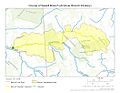
This map shows the path of Sewell Branch as it flows.
-

This map highlights the entire area of land that drains into Sewell Branch.
.jpg)
.jpg)
