
Pinks Branch facts for kids
Quick facts for kids Pinks Branch |
|
|---|---|


|
|
| Other name(s) | Tributary to Leipsic River |
| Country | United States |
| State | Delaware |
| County | Kent |
| Physical characteristics | |
| Main source | Fork Branch divide about 0.1 miles southwest of Shorts Corner, Delaware 70 ft (21 m) 39°11′41″N 075°40′50″W / 39.19472°N 75.68056°W |
| River mouth | Leipsic River about 1 mile east of Kenton, Delaware 23 ft (7.0 m) 39°13′55″N 075°38′11″W / 39.23194°N 75.63639°W |
| Length | 7.52 mi (12.10 km) |
| Basin features | |
| Progression | generally northeast |
| River system | Leipsic River |
| Basin size | 5.59 square miles (14.5 km2) |
| Tributaries |
|
| Bridges | DE 11 (x 2), Judith Road, Shaws Corner Road, Seven Hickories Road |
Pinks Branch is a small stream, about 5.59 mi (9.00 km) long, located in Kent County, Delaware. It's a tributary, which means it's a smaller stream that flows into a larger river. For Pinks Branch, that larger river is the Leipsic River.
Contents
What's in a Name?
Sometimes, rivers and streams have more than one name! Pinks Branch has been known by a couple of other names throughout history. These names were recorded by the Geographic Names Information System.
- Pinks Creek
- Wolfpit Branch
Where Pinks Branch Starts and Ends
The Source: Where it Begins
Pinks Branch begins near a place called Shorts Corner in Delaware. It starts close to a divide for another stream, the Fork Branch. A divide is like a high point in the land that separates where water flows. From this starting point, Pinks Branch is about 70 ft (21 m) above sea level.
The Mouth: Where it Joins a Bigger River
After flowing for about 7.52 mi (12.10 km), Pinks Branch reaches its mouth. This is where it flows into the Leipsic River. The mouth of Pinks Branch is located about 1 mile east of Kenton, Delaware. At this point, the stream is about 23 ft (7.0 m) above sea level.
The Land Around Pinks Branch
The area that Pinks Branch drains is called its watershed. Think of a watershed as all the land where rain and snowmelt collect and then flow into a specific river or stream.
The Pinks Branch watershed covers an area of about 5.59 square miles (14.5 km2). This means that all the water that falls on this land eventually makes its way into Pinks Branch. On average, this area gets about 44.8 inches of rain and other precipitation each year. About 6.5% of the land in this watershed is covered by forests.
Images for kids
-
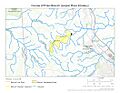
This map shows the path of Pinks Branch.
-
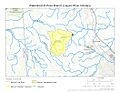
This map highlights the watershed area of Pinks Branch.
.jpg)
.jpg)
