
Fork Branch (St. Jones River tributary) facts for kids
Quick facts for kids Fork Branch |
|
|---|---|

Fork Branch in Dover, Delaware
|
|


|
|
| Other name(s) | Tributary to St. Jones River |
| Country | United States |
| State | Delaware |
| County | Kent |
| City | Dover |
| Physical characteristics | |
| Main source | Pinks Branch and Jordan Branch divides about 0.1 miles west of Seeneytown, Delaware 70 ft (21 m) 39°11′47″N 075°39′42″W / 39.19639°N 75.66167°W |
| River mouth | St. Jones River Silver Lake in Dover, Delaware 14 ft (4.3 m) 39°10′57″N 075°32′55″W / 39.18250°N 75.54861°W |
| Length | 9.48 mi (15.26 km) |
| Basin features | |
| Progression | east then southeast |
| River system | St. Jones River |
| Basin size | 30.64 square miles (79.4 km2) |
| Tributaries |
|
| Bridges | Shaws Corner Road, Rose Dale Lane, Pearsons Corner Road, Kenton Road, McKee Road, W Denny Road, Scarborough Road, College Road, North State Street |
Fork Branch is a cool little river, about 9.48 mi (15.26 km) long, located in Kent County, Delaware. It's like a smaller stream that flows into a bigger river called the St. Jones River.
Contents
What's in a Name?
Did you know that Fork Branch hasn't always been called Fork Branch? Long ago, people knew this river by different names. The Geographic Names Information System tells us some of these old names. They include:
- Cranbrook River
- Downs Branch
- Fisher Branch
- Warge Kijhlen
- Wulfs Creek
It's pretty interesting how names can change over time!
Where Does It Start?
Every river has a beginning! Fork Branch starts in a place near Seeneytown, Delaware. It begins where two smaller streams, Pinks Branch and Jordan Branch, meet. From there, the water starts its journey.
The River's Journey
Fork Branch flows for almost 9.48 mi (15.26 km). It starts by heading east, then turns to the southeast. Along its way, other smaller streams join it, adding more water. These joining streams are called tributaries. On the left side, Maidstone Branch and McKees Run flow into Fork Branch.
Finally, Fork Branch reaches its end point. It flows into the St. Jones River at Silver Lake, which is located in Dover, Delaware.
What is a Watershed?
A watershed is like a giant bowl that collects all the rain and snowmelt in an area. All the water in that "bowl" eventually flows into one main river or lake. The Fork Branch watershed covers about 30.64 square miles (79.4 km2). This means all the rain that falls in this area will eventually make its way into Fork Branch.
About 10.5% of the land in this watershed is covered by forests. These forests are important because they help keep the water clean. They also provide homes for many animals.
Bridges Over the Water
Many roads cross over Fork Branch. This means there are several bridges that help people get around. Some of the roads that cross the river include:
- Shaws Corner Road
- Rose Dale Lane
- Pearsons Corner Road
- Kenton Road
- McKee Road
- W Denny Road
- Scarborough Road
- College Road
- North State Street
Images for kids
-
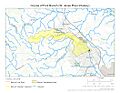
This map shows the path of Fork Branch.
-
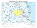
This map shows the entire watershed area of Fork Branch.
.jpg)
.jpg)
