Sha Tin Airfield facts for kids
Quick facts for kids
Shatin Airfield
RAF Shatin
|
|||||||||||
|---|---|---|---|---|---|---|---|---|---|---|---|

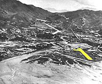
Runway of Sha Tin Airfield (highlighted in yellow)
|
|||||||||||
| Summary | |||||||||||
| Airport type | Military, Defunct | ||||||||||
| Owner | RAF, Army Air Corps | ||||||||||
| Operator | RAF, Army Air Corps | ||||||||||
| Serves | Shatin, New Territories | ||||||||||
| Location | Sha Tin | ||||||||||
| Elevation AMSL | 26 ft / 8 m | ||||||||||
| Coordinates | 22°22′49″N 114°11′23″E / 22.38024°N 114.18983°E | ||||||||||
| Runway | |||||||||||
|
|||||||||||
Sha Tin Airfield was a small military airport in Sha Tin, Hong Kong. It had one concrete runway and was located by the Shing Mun River, facing Tide Cove. This airfield was mainly used by military aircraft.
A powerful storm called Typhoon Wanda badly damaged the airfield in 1962. It was taken down in the early 1970s. The land was then used to build new parts of Shatin city.
Where Was It?
The airfield was in Sha Tin, Hong Kong. It was close to the Sha Tin station of the old Kowloon-Canton Railway. Today, this area is home to the Hong Kong Heritage Museum and the Royal Park Hotel. The airfield was built on the shallow edge of Tide Cove.
A Brief History
Sha Tin Airfield was built in 1949 for the Royal Air Force (RAF), which is the UK's air force. It was called RAF Shatin for a short time. Later, it was given to the British Army's Army Air Corps (AAC).
During the 1950s and 1960s, different special units of the AAC, called Air Observation Post Flights, came to Hong Kong from Britain. These units used small planes to help soldiers on the ground by watching from above. The airfield operated the Auster AOP.6 aircraft.
Interestingly, a Belgian pilot named Charles den Bron flew his plane, the Spirit of Shatin, from an airfield in this area way back in 1911.
In the late 1950s, a private club used the airfield to fly remote-controlled model airplanes. They stayed there until 1970.
The End of the Airfield
In 1962, Typhoon Wanda caused a lot of damage to the airfield. The storm surge, which is a big wall of water, hit the area hard. Because of the damage, the military operations moved to Kai Tak airport around 1963.
The airfield was completely taken down in the early 1970s. The land was then used to build the new Sha Tin New Town, which is a large residential area.
What Was There?
The airfield had one runway that was about 600 metres long. It also had a small control tower, a building, and hangars (which are like garages for planes) made of metal.
After Typhoon Wanda in 1962, the airfield was no longer used. All the buildings were taken down when the base closed in the 1970s. The main building for the Air Observation Post was located near Tide Cove, facing Tolo Harbour.
Today, the runway area is where you'll find the Hong Kong Heritage Museum, New Town Plaza Phase 3, and the Royal Park Hotel. The rest of the former base is now Sha Tin Park.
See also
- Military of Hong Kong
- British Forces Overseas Hong Kong
- Sek Kong Airfield
- RAF Kai Tak
- Aviation history of Hong Kong
 | Sharif Bey |
 | Hale Woodruff |
 | Richmond Barthé |
 | Purvis Young |

