
Shades Mountain facts for kids
Quick facts for kids Shades Mountain |
|
|---|---|

Shades Mountain
Location in Alabama
|
|
| Highest point | |
| Elevation | 1,109 ft (338 m) |
| Geography | |
| Location | Jefferson County, Alabama, U.S. |
| Climbing | |
| Easiest route | Hike |
Shades Mountain is a natural landform in Jefferson County, Alabama. It is located in the state of Alabama in the United States. This mountain is a type of cuesta. A cuesta is a hill or mountain with one side that slopes gently and another side that is very steep.
Shades Mountain is bordered by Shades Crest Road to the west. Highway 150 is to its south, and Highway 280 is to the east. Shades Creek runs along its northern side. The mountain includes the neighborhood of Bluff Park in Hoover, Alabama. This is where the mountain reaches its highest point. Parts of the cities of Homewood, Vestavia Hills, and Mountain Brook are also on Shades Mountain.
Contents
What is Shades Mountain Made Of?
The rocks that make up Shades Mountain are very old. One special type of rock found here is called "Shades Sandstone." You can easily see these rocks at Moss Rock Preserve. This preserve is located in Hoover, on the north side of Hurricane Creek. Looking at these rocks helps scientists understand the history of the Earth.
Cool Places to Visit
Shades Mountain has some interesting spots to explore.
Lover's Leap
There is a famous rock sticking out called Lover's Leap. You can find it on Shades Crest Road. It's a great place to look out over the area.
Brock Gap
Another important spot is Brock Gap. This is where a part of Shades Mountain was blasted away. This was done to create a path for trains to pass through. It shows how people changed the landscape for transportation.
Tip Top Grill
You might also hear about the Tip Top Grill. This local restaurant is well-known for its amazing views. From here, you can see a large part of the surrounding area. It's a popular spot to enjoy a meal and the scenery.
Images for kids
-
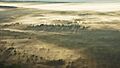
A view of Shades Mountain.
.jpg)
