Shady Grove, Cherokee County, Oklahoma facts for kids
Quick facts for kids
Shady Grove
|
|
|---|---|

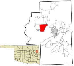
Location within Cherokee County and the state of Oklahoma
|
|
| Country | United States |
| State | Oklahoma |
| County | Cherokee |
| Area | |
| • Total | 12.59 sq mi (32.61 km2) |
| • Land | 12.59 sq mi (32.61 km2) |
| • Water | 0.00 sq mi (0.00 km2) |
| Elevation | 761 ft (232 m) |
| Population
(2020)
|
|
| • Total | 519 |
| • Density | 41.23/sq mi (15.92/km2) |
| Time zone | UTC-6 (Central (CST)) |
| • Summer (DST) | UTC-5 (CST) |
| FIPS code | 40-66510 |
| GNIS feature ID | 2408717 |
Shady Grove is a small community in Cherokee County, Oklahoma, United States. It is known as a census-designated place (CDP). This means it's an area that the government counts as a community for statistics, even though it doesn't have its own local government like a city or town.
In 2020, about 519 people lived in Shady Grove. It's important not to confuse this Shady Grove with other places that have similar names in Oklahoma, like the one in McIntosh County or Pawnee County.
Contents
Location and Surroundings
Shady Grove is located in the western part of Cherokee County. It doesn't have a main town center. However, there is a school called Shady Grove School. You can find it along Shady Grove Road, in a valley near Double Spring Creek. This school is in the northern part of the community.
Nearby Towns and Cities
Tahlequah is the main city in Cherokee County. It is about 11 miles (18 km) southeast of Shady Grove. Tahlequah is where the county government offices are located.
The closest town to Shady Grove is Hulbert. Hulbert is only about 1 mile (1.6 km) west of the edge of Shady Grove. It is about 4.5 miles (7.2 km) southwest of the Shady Grove School.
Area Size
According to the United States Census Bureau, the entire area of Shady Grove is about 12.6 square miles (32.6 square kilometers). All of this area is land, with no large bodies of water.
Population Details
| Historical population | |||
|---|---|---|---|
| Census | Pop. | %± | |
| 2020 | 519 | — | |
| U.S. Decennial Census | |||
In 2000, there were 484 people living in Shady Grove. These people lived in 181 households. A household is a group of people living together in one home. Out of these, 131 were families.
Community Makeup
The population density was about 38 people per square mile (15 people per square kilometer). This means there weren't many people living in a small area.
Most of the people in Shady Grove were White (57.23%). A significant number were Native American (35.95%). Some people identified as being from two or more races (5.58%). A small number were African American (0.41%) or from other races (0.83%). About 3.93% of the population identified as Hispanic or Latino.
Households and Families
Many households in Shady Grove had children under 18 living with them (35.4%). Most households were married couples living together (60.2%). About 9.9% of households had a female head of the house with no husband present.
The average household had 2.67 people. For families, the average size was 3.22 people.
Age Distribution
The population in Shady Grove was spread across different age groups:
- 29.3% were under 18 years old.
- 8.3% were between 18 and 24 years old.
- 30.6% were between 25 and 44 years old.
- 21.3% were between 45 and 64 years old.
- 10.5% were 65 years old or older.
The median age was 34 years. This means half the people were younger than 34, and half were older.
Income Information
In 2000, the median income for a household in Shady Grove was $27,273 per year. For families, the median income was $34,196 per year. The per capita income (income per person) was $11,343.
About 17.5% of the total population lived below the poverty line. This included 22.8% of those under 18 and 8.5% of those 65 or older.
See also
 In Spanish: Shady Grove (condado de Cherokee) para niños

