
Sheridan Township, Clare County, Michigan facts for kids
Quick facts for kids
Sheridan Township, Michigan
|
|
|---|---|

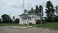
Sheridan Township Hall
|
|
,_MI_location.png)
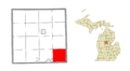
Location within Clare County
|
|

Sheridan Township, Clare County, Michigan
Location in Michigan

Sheridan Township, Clare County, Michigan
Location in the United States
|
|
| Country | United States |
| State | Michigan |
| County | Clare |
| Established | 1870 |
| Area | |
| • Total | 36.50 sq mi (94.53 km2) |
| • Land | 36.15 sq mi (93.63 km2) |
| • Water | 0.35 sq mi (0.91 km2) |
| Elevation | 791 ft (241 m) |
| Population
(2020)
|
|
| • Total | 1,548 |
| • Density | 42.8/sq mi (16.5/km2) |
| Time zone | UTC-5 (Eastern (EST)) |
| • Summer (DST) | UTC-4 (EDT) |
| ZIP code(s) |
48617 (Clare)
|
| Area code(s) | 989 |
| FIPS code | 26-73000 |
| GNIS feature ID | 1627065 |
Sheridan Township is a community located in Clare County, Michigan, in the United States. It was officially established in 1870. In 2020, about 1,548 people lived here.
Contents
Exploring Sheridan Township
Sheridan Township is a part of Clare County. It is led by a supervisor, William Strouse, and a clerk, Leane Strouse. The township covers an area of about 36.50 square miles (94.53 square kilometers). Most of this area is land, with a small part being water.
Discovering Colonville: A Small Community
- Colonville is a small area within Sheridan Township that doesn't have its own official local government. It is located at 43°50′39″N 84°42′21″W / 43.84417°N 84.70583°W.
- This community started with a rural post office on December 4, 1894. A storekeeper named Curtis Palmer was the first postmaster. The post office was open for about 10 years, closing on January 15, 1904.
Geography and Natural Features
Sheridan Township has a total area of about 36.50 square miles (94.53 square kilometers). Most of this is land (36.15 square miles or 93.63 square kilometers). A small part, about 0.35 square miles (0.91 square kilometers), is water.
The South Branch of the Tobacco River flows through the southern part of the township. This river is a natural feature that adds to the local landscape.
Who Lives Here? Population Facts
In 2000, there were 1,588 people living in Sheridan Township. The population density was about 43.7 people per square mile. There were 482 households, which are groups of people living together in one home.
- Many households (45.2%) had children under 18 years old living with them.
- Most households (66.0%) were married couples living together.
- The average household had about 3.28 people.
The population of the township was spread out by age:
- About 37.0% of the people were under 18 years old.
- About 9.3% were between 18 and 24 years old.
- About 28.4% were between 25 and 44 years old.
- About 17.5% were between 45 and 64 years old.
- About 7.8% were 65 years old or older.
The average age in the township was 29 years.
Learning and Schools
The entire township of Sheridan is served by Clare Public Schools. These schools are located to the west in the city of Clare. This means that students living in Sheridan Township attend schools in the nearby city.
Images for kids
-
Sheridan Township Hall
-
Location within Clare County
See also
 In Spanish: Municipio de Sheridan (condado de Clare) para niños
