Shire of Perry facts for kids
Quick facts for kids Shire of PerryQueensland |
|||||||||||||||
|---|---|---|---|---|---|---|---|---|---|---|---|---|---|---|---|

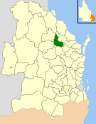
Location within Queensland
|
|||||||||||||||
| Population | 445 (2006 census) | ||||||||||||||
| • Density | 0.18874/km2 (0.4888/sq mi) | ||||||||||||||
| Established | 1880 | ||||||||||||||
| Area | 2,357.7 km2 (910.3 sq mi) | ||||||||||||||
| Council seat | Mount Perry | ||||||||||||||
| Region | Wide Bay-Burnett | ||||||||||||||
 |
|||||||||||||||
| Website | Shire of Perry | ||||||||||||||
|
|||||||||||||||
The Shire of Perry was a special area in Queensland, Australia. It was a type of local government area that helped manage a specific part of the state. This shire was located near the Burnett River. It covered a large area of about 2,357.7 square kilometers (910.3 square miles). The Shire of Perry existed for many years, from 1880 until 2008.
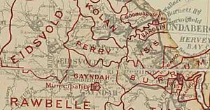
In 2008, the Shire of Perry joined with other nearby shires. They all came together to form a bigger area called the North Burnett Region. The main town and administrative center for the Shire of Perry was Mount Perry.
Contents
What is a Shire?
A shire is a type of local government area in Australia. Think of it like a local council that manages services for a specific region. These services can include roads, parks, libraries, and community events. Shires help make sure that local areas are well-organized and meet the needs of the people living there.
A Look Back: History of the Shire of Perry
The Shire of Perry has a long history. It started out as the Perry Division. This was one of the first divisions created under a special law called the Divisional Boards Act 1879. When it first began, about 1,664 people lived in the area. The very first meeting for the Perry Division happened on March 6, 1880.
How the Shire of Perry Was Formed
Later, a new law was passed in 1902 called the Local Authorities Act. Because of this new law, the Perry Division officially became the Shire of Perry on March 31, 1903. This change helped to update how local areas were governed.
Joining the North Burnett Region
Many years later, on March 15, 2008, a big change happened. The Queensland Parliament passed a law in 2007 to reform local governments. This law meant that the Shire of Perry would merge with five other shires. These shires were Biggenden, Eidsvold, Gayndah, Monto, and Mundubbera. Together, they formed the new North Burnett Region. This merger created a larger, combined local government area.
Towns and Communities in the Shire
The Shire of Perry was home to one main settlement. This was the town of Mount Perry. It served as the central hub for the shire's administration and community life.
Population Changes Over Time
The number of people living in the Shire of Perry changed over the years. Here's a quick look at how the population grew and shrank:
| Year | Population |
|---|---|
| 1933 | 795 |
| 1947 | 628 |
| 1954 | 496 |
| 1961 | 455 |
| 1966 | 374 |
| 1971 | 376 |
| 1976 | 304 |
| 1981 | 309 |
| 1986 | 310 |
| 1991 | 374 |
| 1996 | 351 |
| 2001 | 426 |
| 2006 | 445 |
Leaders of the Shire: Chairmen and Mayors
The Shire of Perry had different leaders over its history. These leaders were called Chairmen or Mayors. They were in charge of making decisions for the shire.
- 1902—1933: Robert Hodnett
- 1933: William John Maynard
- 2008: Joy Jensen
Joy Jensen was the very last mayor of the Shire of Perry before it merged. Even though Perry was the smallest of the six shires that merged, Joy Jensen went on to become the mayor of the new North Burnett Region. She won the election for mayor of the combined region on March 15, 2008.


