Shockoe Bottom facts for kids
|
Shockoe Valley and Tobacco Row Historic District
|
|

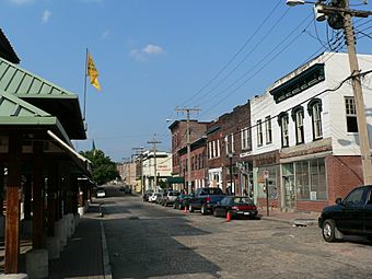
View north on 17th Street
|
|
| Location | Roughly bounded by Dock, 15th, Clay, Franklin, and Pear Streets, Richmond, Virginia |
|---|---|
| Area | 129 acres (52 ha) |
| Architectural style | Mid 19th Century Revival, Late 19th and 20th Century Revivals, Late Victorian |
| NRHP reference No. | 83003308 |
Quick facts for kids Significant dates |
|
| Added to NRHP | February 24, 1983 |
Shockoe Bottom is a historic area in Richmond, Virginia. It sits just east of downtown, right by the James River. This neighborhood is one of Richmond's oldest. It was part of the city's first plan back in 1737. Shockoe Bottom is located between Shockoe Hill and Church Hill.
Contents
A Look Back in Time
Early Days and Tobacco
Shockoe Bottom was first mentioned in 1730. This was in a law called the Tobacco Inspection Act. The law said a tobacco warehouse should be built here. This land belonged to William Byrd II.
Richmond became the state capital later in the 1700s. This helped Shockoe Bottom grow even more. A bridge was built across the James River in 1788. This bridge is now the 14th Street Bridge. Important tobacco buildings were also built nearby. These included a public warehouse and the Federal Customs House.
Historic Buildings and Commerce
Shockoe Bottom is home to several old buildings. One is the Edgar Allan Poe Museum. Another is the Mason's Hall. This building was constructed between 1785 and 1787.
Throughout the 1800s, Shockoe Bottom was Richmond's main business center. Ships would arrive from the James River. Goods from these ships were stored and traded here.
A Difficult Past
From the late 1600s until 1865, this area played a sad role. It was the second largest center for the trade of enslaved people in the country. Only New Orleans was larger. Money from this trade made many white Southerners wealthy. It also boosted Richmond's economy.
Fifteenth Street was even called Wall Street back then. More than 69 slave dealers and auction houses were in the area. In 2006, digging began at the site of Lumpkin's Jail. This was a notorious jail for enslaved people.
Nearby is the African American Burial Ground. For a long time, this sacred place was used as a parking lot. In 2011, after years of community effort, it became a memorial park.
Rebuilding After the Fire
In April 1865, the American Civil War was ending. Confederate forces were leaving Richmond. They were ordered to burn tobacco warehouses. The fires spread and destroyed Shockoe Bottom.
But the area was quickly rebuilt in the late 1860s. It grew even more in the 1870s. Many buildings you see today were built after the 1865 fire. They often show the Italianate style. A fountain from 1909 is also here. It honors "one who loved animals."
These buildings once held offices, shops, and warehouses. Today, they are mostly restaurants, stores, offices, and apartments. The area started to decline in the 1920s. Other parts of the city became more important with cars. Many buildings were torn down, including the Tobacco Exchange. Large tobacco companies were in Tobacco Row until the 1980s.
Modern Changes and Future Plans
Flood Protection and New Homes
The James River used to flood Shockoe Bottom often. But in 1995, the James River Flood Wall was finished. The Canal Walk was also completed. These projects greatly helped the area.
However, in 2004, Hurricane Gaston caused a different kind of flood. Shockoe Creek overflowed. This damaged many businesses and buildings.
In the mid-1990s, old warehouses in Tobacco Row were turned into apartments. This led to a big increase in people living here. Since then, more empty buildings have become homes. New buildings have also been built.
Protecting History and New Ideas
In 2014, the National Trust for Historic Preservation called Shockoe Bottom one of America's 11 Most Endangered Historic Places. This was because of a plan called "Revitalize RVA." This plan suggested building a baseball stadium, a museum about slavery, a hotel, a grocery store, and new offices and homes.
As of 2020, there are ongoing efforts. People are working to build a museum about slavery in Shockoe Bottom. This museum would honor the Lumpkins Slave Jail site.
 |
Court End | Upper Shockoe Valley | Union Hill |  |
| Capitol Hill Shockoe Slip |
Church Hill | |||
| Manchester Mayo Bridge over the James River |
Rockett's Landing |
 | Charles R. Drew |
 | Benjamin Banneker |
 | Jane C. Wright |
 | Roger Arliner Young |


