Shoe Island / Motuhoa facts for kids
|
Motuhoa (Māori)
|
|
|---|---|

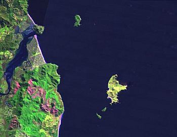
LANDSAT image showing Shoe Island (centre top), Slipper Island (lower right), and surround area
|
|
| Geography | |
| Location | Waikato region |
| Coordinates | 36°59′30″S 175°54′20″E / 36.99167°S 175.90556°E |
| Area | 0.40 km2 (0.15 sq mi) |
| Length | 1.1 km (0.68 mi) |
| Width | 0.6 km (0.37 mi) |
| Highest elevation | 124 m (407 ft) |
| Administration | |
| Demographics | |
| Population | uninhabited |
Shoe Island / Motuhoa is a small island located off the east coast of New Zealand. It covers about 40 hectares (99 acres) of land. This island is found near the Coromandel Peninsula, a beautiful part of New Zealand.
Shoe Island sits right at the entrance to Tairua Harbour. You can also spot a larger island called Slipper Island to its southeast.
Discover Shoe Island / Motuhoa
This island is quite steep, meaning it rises sharply from the water. At its northern end, there is a reef, which is a rocky area under the water. The highest point on Shoe Island reaches about 124 metres (407 ft) above sea level. Imagine standing at the top and seeing the ocean all around!
What Makes Shoe Island Special?
Shoe Island is known for its amazing natural beauty. It was formed by volcanoes a long time ago. The main rock type you'll find here is called rhyolite, which is a type of volcanic rock.
The inside of the island is covered with native plants and trees that have grown strong despite the wind. Along the coast, you can see bare cliffs. Because not many people visit or live on Shoe Island, it has stayed in a very natural and untouched condition. This makes it a special place where nature thrives.
 | Calvin Brent |
 | Walter T. Bailey |
 | Martha Cassell Thompson |
 | Alberta Jeannette Cassell |

