Sidi Bel Abbès Province facts for kids
Quick facts for kids
Sidi Bel Abbès Province
ولاية سيدي بلعباس
|
|
|---|---|

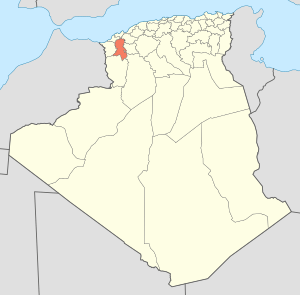
Map of Algeria highlighting Sidi Bel Abbès
|
|
| Country | |
| Capital | Sidi Bel Abbès |
| Area | |
| • Total | 9,150.63 km2 (3,533.08 sq mi) |
| Population | |
| • Total | 603,369 |
| • Density | 65.93743/km2 (170.77715/sq mi) |
| Time zone | UTC+01 (CET) |
| Area Code | +213 (0) 48 |
| ISO 3166 code | DZ-22 |
| Districts | 15 |
| Municipalities | 52 |
Sidi Bel Abbès is a province in the country of Algeria. It is located in the northwestern part of Algeria. The province is named after its main city, Sidi Bel Abbès.
Contents
About Sidi Bel Abbès Province
Sidi Bel Abbès Province covers an area of about 9,150 square kilometers. In 2008, more than 600,000 people lived there. The capital city of the province is Sidi Bel Abbès.
The province is led by a Wāli, who is like a governor. The current Wāli is Mr. Mokhtar Bentabet. There is also a People's Provincial Assembly (PPA), which helps make decisions for the province.
Parts of the Province
Sidi Bel Abbès Province is divided into smaller areas to help manage it. These areas are called districts and municipalities.
Districts of Sidi Bel Abbès
The province has 15 main districts. Each district includes several smaller towns or areas.
- Aïn El Berd
- Ben Badis
- Marhoum
- Mérine
- Mostefa Ben Brahim
- Moulay Slissen
- Ras El Ma
- Sfisef
- Sidi Ali Benyoub
- Sidi Ali Boussidi
- Sidi Bel Abbès
- Sidi Lahcène
- Télagh
- Ténira
- Téssala
Municipalities
Within these 15 districts, there are 52 smaller areas called communes or municipalities. These are like local towns and villages.
See also
 In Spanish: Provincia de Sidi Bel Abbes para niños
 | George Robert Carruthers |
 | Patricia Bath |
 | Jan Ernst Matzeliger |
 | Alexander Miles |

