
Sierra de Codés facts for kids
Quick facts for kids Codés Range |
|
|---|---|

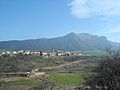
The Codés Range rising behind Aguilar de Codés
|
|
| Highest point | |
| Elevation | 1,418 m (4,652 ft) |
| Naming | |
| Language of name | Lua error in Module:ISO_639_name at line 108: attempt to index local 'data' (a nil value). |
| Geography | |
| Location | Navarre, Spain |
| Parent range | Basque mountains |
| Climbing | |
| First ascent | unknown |
| Easiest route | climb |
The Codés Range is a group of mountains in western Navarre, Spain. It is part of the larger Basque Mountains. In the Basque language, it is called Kodesko mendilerroa, and in Spanish, it is Sierra de Codés.
The highest point in the Codés Range is a peak called Ioar. It stands 1,418 meters (about 4,652 feet) tall. Ioar is located between the towns of Santa Cruz de Campezo and Aguilar de Codés. The Codés Range is the most western mountain range in Navarre. It sits right on the border with the Álava Province.
A special place called the Santuario de Nuestra Señora de Codés is found in these mountains. It is located near the town of Torralba del Río.
In winter, the mountains in the Codés Range often get covered in snow. This is similar to the nearby Andia and Urbasa ranges, which are further north.
Tallest Peaks
The Codés Range has several important peaks. Here are some of the highest ones:
- Ioar, 1,418 meters (the highest point)
- Kodes, 1,414 meters
- Grudo, 1,363 meters
- Laplana, 1,337 meters
- Peña Blanca, 1,249 meters
- San Cristobal, 1,245 meters
- Costalera, 1,234 meters
- Peña Redonda, 1,207 meters
- Peña Gallet, 1,158 meters
- Humada, 1,155 meters
- Malpica, 1,087 meters
- La Corolla, 1,072 meters
Images for kids
-
The Codés Range seen from Aguilar de Codés.
See also
In Spanish: Sierra de Codés para niños
