
Sigsbee Deep facts for kids
The Sigsbee Deep is the deepest part of the Gulf of Mexico. It's a large, roughly triangular basin (like a big bowl on the ocean floor). It was named after Commander Charles Dwight Sigsbee of the U.S. Coast and Geodetic Survey. He was the captain of the ship USC&GS George S. Blake, which found and mapped this deep area. Sometimes, it's also called the Mexico Basin.

What is the Sigsbee Deep?
The Sigsbee Deep is in the southwestern part of the Gulf of Mexico. The closest point to the U.S. coast is about 200 miles (320 km) southeast of Brownsville, Texas.
The exact depth of the Sigsbee Deep is a bit debated. Estimates range from about 12,300 feet (3,750 meters) to 14,380 feet (4,384 meters). To give you an idea, the average depth of the whole Gulf of Mexico is about 5,300 feet (1,615 meters).
Inside the Sigsbee Deep, there's an even flatter and deeper area called the Sigsbee Abyssal Plain. An "abyssal plain" is a very flat, deep part of the ocean floor.
Why does it have two names?
The name "Sigsbee Deep" comes from Commander Charles Dwight Sigsbee. His ship, the George S. Blake, explored and mapped the Gulf of Mexico in the late 1800s. He was a pioneer in using special equipment to measure deep ocean depths. "Sigsbee Deep" appeared on some of the very first maps of the Gulf.
The U.S. government's Board on Geographic Names (BGN) officially calls this area the Mexico Basin for their maps. However, many scientists and international groups still use "Sigsbee Deep." So, you might see it called by either name!
Commander Sigsbee was very important for mapping the deep ocean. Because of his work, other features in the Gulf of Mexico are also named after him:
- Sigsbee Plain
- Sigsbee Knolls
- Sigsbee Escarpment (a steep slope on the ocean floor)
Images for kids
-
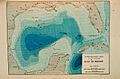
Contour map of Gulf of Mexico as sounded by the C&GS Steamer Blake between 1873 and 1875. Over 3,000 soundings went into this chart, most of the deep water soundings taken by the Sigsbee Sounding Machine. This was the first realistic bathymetric map of any oceanic basin. In: "Three Cruises of the BLAKE" by Alexander Agassiz, 1888. P. 102.
See also
 In Spanish: Fosa de Sigsbee para niños
