
Sindh Valley facts for kids
Quick facts for kids Sind Valley |
|
| Valley | |
 The Sind Valley at Wayil
|
|
| Country | India |
|---|---|
| State | Jammu and Kashmir |
| Region | Kashmir Division |
| District | Ganderbal |
| Municipality | Kangan |
| Range | Himalaya |
| Borders on | Zojila (East) Kashmir Valley (West) |
| River | Sind River |
| Highest point | |
| - location | Baltal |
| - elevation | 9,364 ft (2,854 m) |
| - coordinates | 34°15′22″N 75°25′8″E / 34.25611°N 75.41889°E |
| Lowest point | |
| - location | Wayil |
| - elevation | 5,505 ft (1,678 m) |
| - coordinates | 34°17′21″N 74°48′45″E / 34.28917°N 74.81250°E |
| Length | 40 mi (64 km) |
| Width | 0.6 mi (1 km) |
| Population | 97,874 (2001) |
| Easiest access | NH 1D |
The Sindh Valley is a beautiful valley located in the Himalayas mountain range. It is found north of Srinagar in Jammu and Kashmir, India. This valley starts in a place called Gandarbal and stretches all the way to Baltal. It is also close to the beginning of the Zojila Pass.
The Sindh Valley has always been a very important pathway. For a long time, it was the main route connecting Kashmir with Central Asia. Imagine all the traders and travelers who used this valley!
Contents
Exploring the Sind Valley
The Sind Valley is about 40 miles (64 kilometers) long. It is quite narrow, only about 0.6 miles (1 kilometer) wide. The valley follows the path of the Sind River, which flows through it.
Where is it located?
The valley is in the Ganderbal district of Jammu and Kashmir. It is part of the larger Kashmir Valley. To the east, it borders the Zojila Pass. To the west, it connects with the main Kashmir Valley.
How high is the valley?
The highest point in the valley is near Baltal. This area is about 9,364 feet (2,854 meters) above sea level. The lowest part of the valley is near Wayil, which is about 5,505 feet (1,678 meters) high.
Life in the Valley
In 2001, about 97,874 people lived in the Sind Valley. Many small villages are scattered throughout the valley. One such village is Gund. People in the valley often rely on the river and the land for their lives.
Getting around
The main road that goes through the valley is called NH 1D. This road makes it easier for people to travel and for goods to be moved. It helps connect the valley to other parts of the region.
Images for kids
-
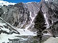
Sind Valley at Domail Baltal
-
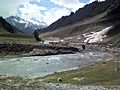
Sind River at Sonamarg
-
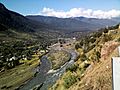
Sind Valley at Gatribal
-
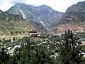
Gund, a village in Sind Valley


