Kori Creek facts for kids
The Kori Creek (Gujarati: કોરી ખાડી, Urdu: کوری کریک) is a water channel that flows into the Arabian Sea. It's a "tidal creek," meaning its water levels change with the ocean's tides. This creek is located in a marshy area called the Rann of Kutch. This area is found between the Gujarat state in India and the Sindh province in Pakistan.
The Kori Creek is about 96 kilometers (60 miles) long. Both India and Pakistan claim this strip of water as their own. This disagreement is part of a larger Border dispute between the two countries. The main problem is deciding exactly where the border should be drawn in and around the creek.
The creek itself is in a quiet, marshy area where no one lives. During the monsoon season (June to September), the creek overflows. It covers the flat, salty mud areas around it. In winter, many different birds, like flamingos, come to visit this area.
Contents
Understanding the Kori Creek Dispute
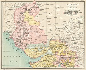
The disagreement over the Kori Creek started because of old maps. These maps from 1914 and 1925 show different ideas for the border between Kutch and Sindh. Back then, this whole region was part of Bombay Presidency in undivided India.
After India became independent in 1947, Sindh joined Pakistan. Kutch became part of India. This made the old map lines even more important.
Why the Border is Disputed
One map from 1914 suggests the border is along the eastern side of the creek. This line is called the "Green Line." Pakistan believes this is the correct border.
However, India disagrees. India says another map from 1925 shows the border in the middle of the creek. This idea is based on something called the "Thalweg Doctrine." This is an international rule that says if a river or channel forms a border between two countries, the border can be in the middle of the deepest part of the channel. India says the Kori Creek is deep enough at high tide for boats, so this rule should apply.
Pakistan argues that the Thalweg Doctrine only applies to rivers that are always navigable (meaning boats can always travel on them). They say the Kori Creek isn't always deep enough. Also, the creek has changed its path over the years. If the border moves to the middle of the creek, Pakistan would lose some land. They would also lose part of their "Exclusive Economic Zone" (EEZ) in the sea. An EEZ is an area up to 370 kilometers (200 nautical miles) from a country's coast where it has special rights to explore and use resources.
Past Conflicts and Attempts to Resolve the Dispute
The dispute over the Kori Creek has even led to fighting. In April 1965, a conflict here contributed to the Indo-Pakistani War of 1965. Later that year, the British Prime Minister helped both countries agree to set up a special group, called a tribunal, to solve the problem. In 1968, the tribunal decided that Pakistan would get about 10% of the land it claimed.
Another serious event happened in 1999. An Indian Air Force jet shot down a Pakistani Navy plane over the Kori Creek. India said the plane was in its airspace, but Pakistan disagreed.
Economic Importance of Kori Creek
Even though the Kori Creek might not seem important for military reasons, it has a lot of economic value. The area under the sea near the creek is believed to have large amounts of oil and natural gas. Whichever country controls the creek would have a big advantage in getting these energy resources.
Also, clearly defining the border in the creek helps set the maritime (sea) boundaries. These sea boundaries are important for determining each country's Exclusive Economic Zone (EEZ). Within their EEZ, countries can explore for oil, gas, and other resources.
A clear border would also help prevent fishermen from both countries from accidentally crossing into the other's territory. This is a common problem that leads to fishermen being arrested.
Efforts to Solve the Kori Creek Dispute
Since 1969, India and Pakistan have held eight rounds of talks to try and solve the Kori Creek dispute. However, they haven't found a solution yet.
India has suggested that they first draw the maritime (sea) boundary. This would follow international rules for sea borders. But Pakistan has refused this idea. Pakistan believes the land dispute over the creek itself must be solved first.
Pakistan has also suggested asking an international third party to help solve the dispute. This is called "international arbitration." However, India has said no to this. India believes that all disagreements between the two countries should be solved by India and Pakistan talking directly, without anyone else getting involved.


