Sophia Range facts for kids
Quick facts for kids Sophia Range |
|
|---|---|
| Dimensions | |
| Area | 150 km2 (58 sq mi) |
| Geography | |
| Country | Canada |
| State/Province | British Columbia |
| Range coordinates | 49°49′N 126°51′W / 49.817°N 126.850°W |
| Parent range | Vancouver Island Ranges |
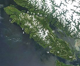
The Sophia Range is a small group of hills and mountains in British Columbia, Canada. It is found on the southern part of Nootka Island. This area forms a peninsula, which is a piece of land almost surrounded by water. It sits between Esperanza Inlet and Nuchatlitz Inlet, west of Tahsis Inlet.
About the Sophia Range
The Sophia Range is made up of low hills. It covers an area of 150 square kilometers. This range is part of a larger group of mountains called the Vancouver Island Ranges. These ranges are themselves part of an even bigger mountain system known as the Insular Mountains.
How the Sophia Range Got Its Name
The Sophia Range was named in the 1850s. At that time, Captain Edward E. Langford had five daughters. They were very popular young women in Victoria. Captain George H. Richards decided to name this mountain range after Sophia Elizabeth. She was the fourth daughter of Captain Langford.
 | Roy Wilkins |
 | John Lewis |
 | Linda Carol Brown |


