South-West Oxford facts for kids
Quick facts for kids
South-West Oxford
|
|
|---|---|
|
Township (lower-tier)
|
|
| Township of South-West Oxford | |
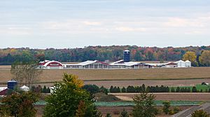
Farm in South-West Oxford
|
|
| Country | Canada |
| Province | Ontario |
| County | Oxford |
| Formed | 1975 |
| Area | |
| • Land | 370.73 km2 (143.14 sq mi) |
| Population
(2016)
|
|
| • Total | 7,664 |
| • Density | 20.7/km2 (54/sq mi) |
| Time zone | UTC-5 (EST) |
| • Summer (DST) | UTC-4 (EDT) |
| Postal Code |
N0J
|
| Area code(s) | 519, 226, 548 |
| Website | www.swox.org |
South-West Oxford is a township in the Canadian province of Ontario. It is part of Oxford County. In 2016, about 7,664 people lived here. South-West Oxford is mostly a countryside area. It was formed in 1975 when the townships of Dereham and West Oxford joined together with the village of Beachville.
Contents
How South-West Oxford is Governed
The township is led by a council. This council includes a mayor and six councillors. The mayor is chosen by all the voters in the township. Councillors are chosen by voters in their specific areas, called wards.
Council members serve for four years. The current council's term ends in November 2022. In the 2018 election, the mayor and four councillors were elected without anyone running against them. This is called acclamation.
Mayor David Mayberry started as a township councillor in 1994. He was first elected mayor in 2006. From 2015 to 2018, he also served as the warden for Oxford County. A warden is like a chairperson for the county council.
The current councillors are:
- David Mayberry - Mayor
- Paul Buchner - Ward 1
- Peter Ypma - Ward 2
- Valerie Durston - Ward 3
- George Way - Ward 4
- Jim Pickard - Ward 5
- Craig Gillis - Ward 6
Geography and Landscape
South-West Oxford stretches from the middle of Oxford County down to its southern edge. The northern border follows the Thames River. However, some parts near Woodstock and Ingersoll have been changed. This was done to include developed areas within those towns.
Long ago, the area that was Dereham township had many swamps and marshy lands. This made it hard to use the land for farming. Big drainage projects helped a lot. These projects are still important for the township's farms today. You can still see large forested areas. These are what's left of the original swamps.
Limestone Deposits
In the northern part of the township, there is a very pure limestone rock deep underground. This limestone is found between Ingersoll and Beachville. People have been digging up this limestone and heating it to make lime since the early days. Since the 1950s, large industrial operations have been mining it. They dig pits that are more than 100 feet deep. There is enough limestone for these operations to continue for over a hundred years.
When these quarries are empty, the plan is for them to fill with water. This would create large lakes that people could use for fun activities.
Nature Reserves
South-West Oxford is home to the Trillium Woods Provincial Nature Reserve. This is a special area that protects wildflowers. It is popular with visitors. The park has five different colors of the common white trillium flower.
History of South-West Oxford
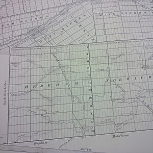
South-West Oxford includes lands from two older townships: West Oxford and Dereham. West Oxford was one of the first areas settled in Oxford County. Dereham was one of the last.
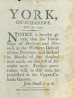
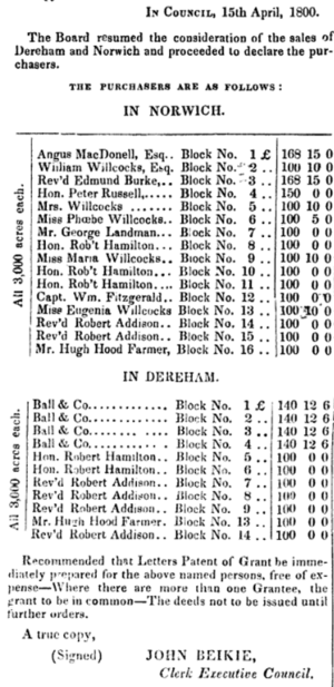
Dereham grew slowly because the government decided to sell all its wilderness land in big chunks in 1799. These lands were bought by people who wanted to make money from them later. They often held onto the land for many years without developing it.
Early Settlements
Wards 4, 5, and 6 of South-West Oxford cover an area once known as Oxford-on-the-Thames. This settlement began in 1793. It was started by Thomas Ingersoll. He was the father of Laura Secord, a Canadian hero from the War of 1812. Ingersoll and his partners were given Oxford township, which was nearly 64,000 acres. They promised to bring at least forty families to settle there.
Ingersoll thought he had a promise from Governor John Graves Simcoe that there were no time limits on this land grant. This was important because it was very hard to build a road and move families from Massachusetts to the Oxford wilderness.
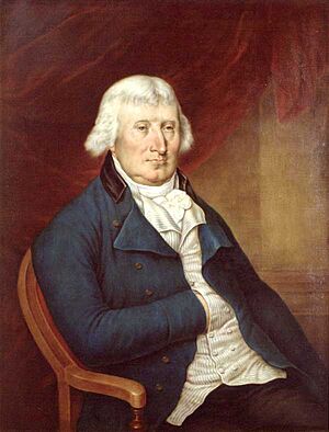
In 1796, Governor Simcoe went back to England. Peter Russell took over as head of the government. He quickly canceled many land grants that Simcoe had made. He said that not enough progress was being made. In 1797, Thomas Ingersoll tried to prove that forty families had settled in his township. The government agreed and gave each family 200 acres. But Thomas Ingersoll only got 1,200 acres for himself. The government took back control of the rest of the township.
Two years later, Peter Russell approved selling all the land in the nearby Dereham and Norwich townships. This was done to raise money for building roads near Toronto. The land was sold for a very small amount of money. This caused a political scandal because many believed the land was sold for only a third of its real value.
Growth and Development
The swampy lands of Dereham remained undeveloped for a long time. In 1817, Robert Gourlay visited Dereham. His wife had inherited nearly 1,000 acres there. He was surprised that the township was still a complete wilderness. He started a public movement to find solutions. But he was arrested and jailed by the government.
In 1824, George Tillson bought 600 acres in the southern part of Dereham. He paid much more than the land had sold for in 1800. Tillson was a foundryman from Massachusetts. He started Dereham Forge, which is now Tillsonburg. His company made stoves and other household items.
Tillson later focused on building sawmills. There was a huge demand for lumber in New York state. Sawn boards were tied together into giant rafts. These rafts floated down Otter Creek from Dereham to Port Burwell to be shipped out.
The lumber trade helped Dereham become more settled. To make business faster, a toll road was built in 1849. It went from Ingersoll through Tillsonburg south to Port Burwell. Tillson believed in having direct roads to markets. He helped build new roads from Tillsonburg to London, Norwich, and St. Thomas.
Communities in South-West Oxford
The Township of South-West Oxford includes several villages and small communities. These include:
- From the former Dereham Township: Brownsville, Brownsville Station, Culloden, Delmer, Dereham Centre, Mount Elgin, Ostrander, Salford, Verschoyle, Zenda (west part)
- From the former West Oxford Township: Beachville, Centreville, Foldens, Hagles Corners, Sweaburg
Beachville
This community was founded in 1791. It was one of the first settlements in Oxford County.
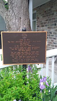
The first officially recorded game of baseball in North America was played here. It happened on June 4, 1838. This was a year before the famous game in Cooperstown. The teams were the Beachville Club and the Zorras.
By 1869, Beachville was a village with 700 people. It had mills, a foundry, churches, schools, and hotels. Beachville is also becoming a popular place for people who enjoy watching birds and hiking the Thames River Trail. The first part of this trail opened in 2011. The goal is to connect Woodstock to Ingersoll.
Centreville
Centreville was one of the first places where European settlers lived. It also had a primary school for grades 1–8 in the 1960s. Centreville Pond is located here.
Dereham Centre
The main offices for the Township of South-West Oxford are located in Dereham Centre.
Mount Elgin
Mount Elgin is located along Highway 19. It is south of Salford and north of Ostrander.
Salford
Salford is a small village with about 50 homes. It is surrounded by farms. The Salford Cheese Store is a notable place here. It is a post office, variety store, and cheese museum all in one. Salford was the birthplace of Aimee Semple McPherson, a famous evangelist.
Sweaburg
Sweaburg is about 5 kilometers southwest of Woodstock. It has Sweaburg United Church and a cemetery. There are also two baseball diamonds.
Attractions to Visit
- Beachville District Museum
- Lawson Nature Reserve
- Trillium Woods Provincial Nature Reserve
- Oxford Hills Golf Club
Climate in South-West Oxford
| Climate data for Foldens, Ontario | |||||||||||||
|---|---|---|---|---|---|---|---|---|---|---|---|---|---|
| Month | Jan | Feb | Mar | Apr | May | Jun | Jul | Aug | Sep | Oct | Nov | Dec | Year |
| Record high °C (°F) | 15.0 (59.0) |
19.0 (66.2) |
24.0 (75.2) |
29.5 (85.1) |
32.5 (90.5) |
35.5 (95.9) |
36.5 (97.7) |
37.0 (98.6) |
33.3 (91.9) |
28.3 (82.9) |
20.6 (69.1) |
18.0 (64.4) |
37.0 (98.6) |
| Mean daily maximum °C (°F) | −2.9 (26.8) |
−1.8 (28.8) |
3.6 (38.5) |
11.2 (52.2) |
18.7 (65.7) |
23.6 (74.5) |
25.9 (78.6) |
25.0 (77.0) |
20.6 (69.1) |
13.7 (56.7) |
6.3 (43.3) |
0.0 (32.0) |
12.0 (53.6) |
| Daily mean °C (°F) | −6.3 (20.7) |
−5.4 (22.3) |
−0.3 (31.5) |
6.5 (43.7) |
13.3 (55.9) |
18.3 (64.9) |
20.7 (69.3) |
19.9 (67.8) |
15.7 (60.3) |
9.4 (48.9) |
3.0 (37.4) |
−3.1 (26.4) |
7.6 (45.7) |
| Mean daily minimum °C (°F) | −9.7 (14.5) |
−9 (16) |
−4.3 (24.3) |
1.7 (35.1) |
7.9 (46.2) |
12.9 (55.2) |
15.4 (59.7) |
14.8 (58.6) |
10.8 (51.4) |
4.9 (40.8) |
−0.3 (31.5) |
−6.2 (20.8) |
3.3 (37.9) |
| Record low °C (°F) | −31 (−24) |
−26.5 (−15.7) |
−22.8 (−9.0) |
−13 (9) |
−4 (25) |
0.0 (32.0) |
4.0 (39.2) |
2.0 (35.6) |
−1.1 (30.0) |
−8.3 (17.1) |
−15.5 (4.1) |
−24 (−11) |
−31 (−24) |
| Average precipitation mm (inches) | 65.6 (2.58) |
51.3 (2.02) |
74.3 (2.93) |
79.4 (3.13) |
77.5 (3.05) |
86.6 (3.41) |
98.8 (3.89) |
93.3 (3.67) |
91.7 (3.61) |
77.1 (3.04) |
87.6 (3.45) |
75.7 (2.98) |
958.9 (37.75) |
| Average rainfall mm (inches) | 32.7 (1.29) |
28.3 (1.11) |
57.2 (2.25) |
73.9 (2.91) |
77.1 (3.04) |
86.6 (3.41) |
98.8 (3.89) |
93.3 (3.67) |
91.7 (3.61) |
76.1 (3.00) |
76.6 (3.02) |
47.2 (1.86) |
839.4 (33.05) |
| Average snowfall cm (inches) | 32.9 (13.0) |
23.1 (9.1) |
17.1 (6.7) |
5.6 (2.2) |
0.4 (0.2) |
0 (0) |
0 (0) |
0 (0) |
0 (0) |
1.0 (0.4) |
11.0 (4.3) |
28.5 (11.2) |
119.5 (47.0) |
| Average precipitation days (≥ 0.2 mm) | 15.8 | 12.3 | 13.3 | 13.6 | 12.6 | 11.1 | 11.6 | 11.4 | 12.6 | 12.5 | 14.9 | 15.2 | 157.0 |
| Average rainy days (≥ 0.2 mm) | 4.6 | 4.5 | 7.7 | 11.8 | 12.5 | 11.1 | 11.6 | 11.4 | 12.6 | 12.5 | 11.4 | 6.5 | 118.1 |
| Average snowy days (≥ 0.2 cm) | 12.2 | 9.0 | 6.6 | 2.5 | 0.13 | 0 | 0 | 0 | 0 | 0.27 | 4.5 | 10.1 | 45.2 |
| Source: Environment and Climate Change Canada | |||||||||||||
Population and Demographics
| South-West Oxford population history | ||
|---|---|---|
| Year | Pop. | ±% |
| 1991 | 8,514 | — |
| 1996 | 8,441 | −0.9% |
| 2001 | 7,782 | −7.8% |
| 2006 | 7,589 | −2.5% |
| 2011 | 7,544 | −0.6% |
| 2016 | 7,664 | +1.6% |
1996 population would have been 7,778 using 2001 boundaries |
||
In the 2021 Census, South-West Oxford had a population of 7,583 people. They lived in 2,616 homes. This was a small change from its 2016 population of 7,634. The township covers a land area of 369.61 square kilometers. This means about 20.5 people live in each square kilometer.
| Canada census – South-West Oxford community profile | |||
|---|---|---|---|
| 2016 | 2011 | 2006 | |
| Population: | 7664 (1.6% from 2011) | 7544 (-0.6% from 2006) | 7589 (-2.5% from 2001) |
| Land area: | 370.73 km2 (143.14 sq mi) | 370.48 km2 (143.04 sq mi) | 370.63 km2 (143.10 sq mi) |
| Population density: | 20.7/km2 (54/sq mi) | 20.4/km2 (53/sq mi) | 20.5/km2 (53/sq mi) |
| Median age: | 39.7 (M: 39.4, F: 39.9) | 39.4 (M: 39.2, F: 39.6) | 37.7 (M: 37.4, F: 37.9) |
| Total private dwellings: | 2690 | 2695 | 2667 |
| Median household income: | $82,509 | $65,664 | |
| References: 2016 2011 2006 earlier | |||
 | Janet Taylor Pickett |
 | Synthia Saint James |
 | Howardena Pindell |
 | Faith Ringgold |


