South Amherst Common Historic District facts for kids
Quick facts for kids |
|
|
South Amherst Common Historic District
|
|

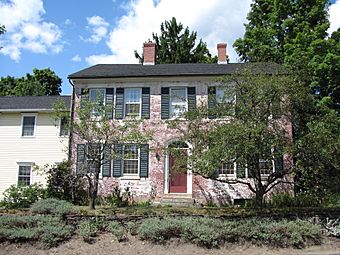
324 Pomeroy Lane
|
|
| Location | 445 Shays Street, South Amherst Common, 979—1081 S. East Street and 324 Pomeroy Lane, Amherst, Massachusetts |
|---|---|
| Area | 13 acres (5.3 ha) |
| Built | 1788 |
| Architect | Putnam, Karl S.; Gos, Philip L., & George Nutting |
| Architectural style | Georgian, Federal, Greek Revival |
| NRHP reference No. | 95000100 |
| Added to NRHP | February 17, 1995 |
The South Amherst Common Historic District is a special area in South Amherst, Massachusetts. It includes a village common (a shared grassy area) and the old buildings around it. This place grew into a busy village center in the 1700s and 1800s. Because of its history and unique look, it was added to the National Register of Historic Places in 1995.
Contents
Discovering South Amherst Common
The town of Amherst started as part of Hadley in the early 1700s. It became its own town in 1759. The South Amherst Common, also called Fiddlers Green, was created around 1760. This happened when new roads were built and connected.
How the Common Grew
The first house known to face the common was built around 1742. It belonged to Nathaniel Coleman and you can still see it today at 1055 South East Street. Another old house, the Jonathan Dickinson House, was built around 1750. It faces the common from 445 Shays Street.
In 1788, the town decided to make its roads a bit smaller. They sold off the extra land but made sure to keep the area that is now South Amherst Common. For the next 150 years, the common became the heart of the local farming community.
What Was at the Common?
Many important things were built around the common. The first school was built in 1764, helping kids learn. A church was built in 1825, becoming a place for people to gather. There were also small businesses, like people making things from their homes.
New roads were added over time. Station Road was built in 1821, heading east from the common. Pomeroy Lane was built in 1825, heading west. Even today, the area still feels a bit like the countryside, though more homes have been built over the years.
What Does the Common Look Like Today?
Today, the common is a roughly triangular grassy area. It's surrounded by South East Street. Other streets like Shays Street, Pomeroy Lane, and Middle Street meet South East Street near the common. The common itself is a simple, green space with trees, but no statues or monuments.
Most of the buildings around the common are homes built in the 1800s. They are mostly made of wood. You can also find a few older homes from the 1700s and some newer ones from the 1900s.
Important Buildings to See
- The Enos Dickinson House: This brick home was built in 1825. For a while, it even held the local post office! It's located at 324 Pomeroy Lane.
- The Congregational Church: Built in 1825, this church is a key part of the common's history.
- The South Amherst School: This school was built in 1902.
- The Munson Memorial Library and Community Center: Built in 1930, this building serves as both a library and a place for community events.


