South East Wales facts for kids

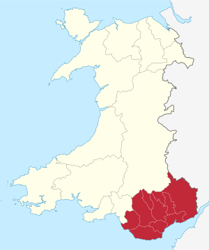
South East Wales is an area in the southeastern part of Wales. It's a busy region with many towns and cities. This area includes the big cities of Cardiff and Newport. It also has many towns located in the South Wales Valleys. South East Wales is often thought of as the preserved counties of Mid Glamorgan, South Glamorgan, and Gwent.
Contents
What is South East Wales?
The name "South East Wales" is used by the Welsh Government. This is the government that runs Wales.
Defining the Region
The Wales Spatial Plan helps define different areas of Wales. For statistics, South East Wales includes ten local areas. These are Vale of Glamorgan, Rhondda Cynon Taf, Merthyr Tydfil, Caerphilly, Cardiff, Newport, Blaenau Gwent, Torfaen, Monmouthshire, and Bridgend.
This area has a population of about 1.43 million people. This was estimated in 2007. It's almost half of everyone living in Wales!
Another group, the South East Wales Biodiversity Records Centre, has a slightly different idea. Their definition includes all of the older counties of Glamorgan and Monmouthshire. This larger area has about 2 million people.
History of Development
The Wales Spatial Plan also talks about how the area grew. For the last 150 years, towns and cities grew in a "hand and fingers" shape. This was because of the Industrial Revolution. Industries like iron, coal, and steel grew fast. They started in the Heads of the Valleys area. Then they spread into the South Wales Valleys and the coastal plain.
Working Together in the Region
Capital Region Tourism helps promote tourism in South East Wales. They are one of four groups that help visitors across Wales.
In 2017, ten local councils in the region formed the Cardiff Capital Region. They agreed to work together on a "city deal." This deal helps them invest in the area.
In 2021, a new group was formed. It's called the South West Wales Corporate Joint Committee. This group helps the ten local councils work together even more. They plan for the economy, future development, and transport.
Main Local Areas
Here is a table showing the main local areas in South East Wales. It includes their population, how many people live per square kilometer, and their size. These numbers are estimates from the Office for National Statistics.
| Principal area | Created | Population | Population density/km2 | Area km2 | Style |
|---|---|---|---|---|---|
| Cardiff | 1996 | 357,200 | 2,534 | 140 | City and county |
| Rhondda Cynon Taf | 1996 | 237,400 | 559 | 424 | County borough |
| Caerphilly | 1996 | 180,200 | 649 | 278 | County borough |
| Newport | 1996 | 147,800 | 775 | 190 | County borough/City |
| Bridgend | 1996 | 142,100 | 566 | 246 | County borough |
| Vale of Glamorgan | 1996 | 127,600 | 385 | 335 | County borough |
| Monmouthshire | 1996 | 92,500 | 108 | 850 | County |
| Torfaen | 1996 | 91,800 | 730 | 126 | County borough |
| Blaenau Gwent | 1996 | 69,500 | 639 | 109 | County borough |
| Merthyr Tydfil | 1996 | 59,300 | 532 | 111 | County borough |
| South East Wales | 2017 | 1,543,293 | 761.8 | 2,809 | Region |
Getting Around South East Wales
Roads
The M4 motorway is a major road that goes through the region. It connects South East Wales to other parts of South Wales and to London. The A470 road is another important route. It links Cardiff on the south coast all the way up to Llandudno on the north coast.
Trains
Main train lines run through South East Wales. They connect to places like Bristol and London on the South Wales Main Line. Other trains go from Cardiff and Newport to Birmingham and Nottingham on the Gloucester to Newport Line. You can also take a train to Manchester on the Welsh Marches Line. There's also a local train network called Valley Lines. It's centered around Cardiff and serves the surrounding areas.
Air Travel
Cardiff Airport is the only international airport in Wales. It allows people to fly to and from other countries.
 | William L. Dawson |
 | W. E. B. Du Bois |
 | Harry Belafonte |

