South Fork Bull Run River facts for kids
Quick facts for kids South Fork Bull Run River |
|
|---|---|

Bull Run River watershed
|
|
|
Location of the mouth of the South Fork Bull Run River in Oregon
|
|
| Country | United States |
| State | Oregon |
| County | Clackamas County |
| Physical characteristics | |
| Main source | Mount Hood National Forest Township Meadow, Clackamas County, Oregon 3,260 ft (990 m) 45°26′02″N 121°59′20″W / 45.43389°N 121.98889°W |
| River mouth | Bull Run River Bull Run Reservoir 2, Clackamas County, Oregon 863 ft (263 m) 45°27′08″N 122°07′21″W / 45.45222°N 122.12250°W |
| Length | 6 mi (9.7 km) |
| Basin features | |
| Basin size | 15.4 sq mi (40 km2) |
The South Fork Bull Run River is a small river, about 6 miles (10 km) long, in Oregon, United States. It is a branch of the Bull Run River. This river is very important because it helps provide drinking water for the city of Portland.
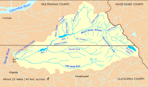
The river flows mostly west through a protected area of the Mount Hood National Forest in Clackamas County. It joins the main Bull Run River at Bull Run Reservoir 2. This meeting point is about 8 miles (13 km) before the Bull Run River flows into the Sandy River. The name "Bull Run" might come from cattle that escaped and roamed freely along the river between 1849 and 1855.
Where Does the River Flow?
The South Fork Bull Run River starts in a place called Township Meadow. This meadow is located within the beautiful Mount Hood National Forest. From its start, the river first flows northwest, then turns and flows west. It travels through Clackamas County and stays within the Mount Hood National Forest.
Along its journey, the South Fork Bull Run River gets water from one other named stream. This stream is called Cedar Creek. Cedar Creek flows into the South Fork from its right side. Not far from where it joins the main Bull Run River, there is a special measuring station. This station, run by the United States Geological Survey (USGS), helps scientists keep track of how much water is flowing.
The South Fork Bull Run River finally meets the main Bull Run River inside Bull Run Reservoir 2. This reservoir is a large lake that holds water.
How Much Water Flows?
Since 1974, the United States Geological Survey (USGS) has been carefully watching the South Fork Bull Run River. They have a special tool called a stream gauge that measures the water flow. This gauge is located about 0.6 miles (1 km) from where the river joins the main Bull Run River.
Between 1974 and 2008, the river's average flow was about 111 cubic feet per second (3.1 cubic meters per second). This measurement comes from an area of 15.40 square miles (39.9 km2) that drains into the river. The highest flow ever recorded was 3,630 cubic feet per second (103 cubic meters per second). This happened on February 7, 1996. The lowest flow was 5.4 cubic feet per second (0.15 cubic meters per second) on October 13, 1994.
What is a Watershed?
A watershed is an area of land where all the water drains into a single river, lake, or ocean. The Bull Run River watershed is a very important area. It covers about 139 square miles (360 km2) of land. This entire area, including the South Fork Bull Run River, is the main source of drinking water for the city of Portland.
Because it provides drinking water, the land in this watershed is very protected. It is mainly used for things like collecting water, storing it, treating it, and managing the forests. The South Fork Bull Run River basin is a part of this larger watershed. It covers about 15.4 square miles (40 km2). This means the South Fork's basin makes up about 11 percent of the entire Bull Run River watershed. The whole watershed is managed by the Portland Water Bureau and the United States Forest Service. They work together to keep the water clean and safe.


