South Laurel, Maryland facts for kids
Quick facts for kids
South Laurel, Maryland
|
|
|---|---|

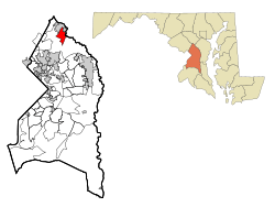
Location of South Laurel, Maryland
|
|
| Country | |
| State | |
| County | |
| Area | |
| • Total | 8.10 sq mi (20.99 km2) |
| • Land | 8.07 sq mi (20.90 km2) |
| • Water | 0.03 sq mi (0.09 km2) |
| Elevation | 161 ft (49 m) |
| Population
(2020)
|
|
| • Total | 29,602 |
| • Density | 3,668.15/sq mi (1,416.25/km2) |
| Time zone | UTC−5 (Eastern (EST)) |
| • Summer (DST) | UTC−4 (EDT) |
| FIPS code | 24-73650 |
| GNIS feature ID | 1867303 |
South Laurel is a community in Prince George's County, Maryland, in the United States. It is an unincorporated area, meaning it's not officially a city or town with its own local government. Instead, it's managed by the county. It's also a census-designated place (CDP), which means the U.S. Census Bureau defines it for gathering population data. In 2020, about 29,602 people lived there.
Contents
Geography
South Laurel is located in Maryland at a specific point on the map: 39 degrees, 4 minutes, 22 seconds North, and 76 degrees, 51 minutes, 4 seconds West.
The community covers a total area of about 21.2 square kilometers (or 8.1 square miles). Most of this area is land, with a very small part (about 0.1 square kilometers or 0.03 square miles) being water.
Demographics
| Historical population | |||
|---|---|---|---|
| Census | Pop. | %± | |
| 2000 | 20,479 | — | |
| 2010 | 26,112 | 27.5% | |
| 2020 | 29,602 | 13.4% | |
| U.S. Decennial Census 2010 2020 |
|||
Every ten years, the United States conducts a census to count its population. This helps us understand how communities are growing and changing.
2020 Census Population Data
The 2020 census showed that South Laurel's population was 29,602 people. The community is home to a diverse group of people from many different backgrounds.
The table below shows the different racial and ethnic groups living in South Laurel in 2010 and 2020. Remember that "Hispanic/Latino" is an ethnic group, and people from this group can be of any race.
| Race / Ethnicity (NH = Non-Hispanic) | Pop 2010 | Pop 2020 | % 2010 | % 2020 |
|---|---|---|---|---|
| White alone (NH) | 4,798 | 3,911 | 18.37% | 13.21% |
| Black or African American alone (NH) | 15,586 | 16,609 | 59.69% | 56.11% |
| Native American or Alaska Native alone (NH) | 50 | 61 | 0.19% | 0.21% |
| Asian alone (NH) | 1,340 | 1,744 | 5.13% | 5.89% |
| Pacific Islander alone (NH) | 6 | 12 | 0.02% | 0.04% |
| Some Other Race alone (NH) | 85 | 177 | 0.33% | 0.60% |
| Mixed Race or Multi-Racial (NH) | 712 | 1,035 | 2.73% | 3.50% |
| Hispanic or Latino (any race) | 3,535 | 6,053 | 13.54% | 20.45% |
| Total | 26,112 | 29,602 | 100.00% | 100.00% |
2010 Census Overview
In 2010, the census counted 26,112 people in South Laurel. There were 8,260 households and 5,055 families living in the area.
About 33.6% of households had children under 18 living with them. The average household had about 2.45 people. The average family had about 3.06 people.
The population was spread out across different age groups. About 26.2% of the people were under 18 years old. The median age, meaning the middle age of all residents, was 31 years.
Education
South Laurel has several schools that serve its young residents.
Primary and Secondary Schools
Students in South Laurel attend schools that are part of the Prince George's County Public Schools system.
There are several elementary schools that serve different parts of South Laurel. These include Deerfield Run, James Harrison, Laurel, Montpelier, Oaklands, and Vansville Elementary Schools.
Most middle school students go to Dwight D. Eisenhower Middle School, which is located in South Laurel. Some students might attend Martin Luther King Middle School in Beltsville. All high school students living in South Laurel are zoned to attend Laurel High School in Laurel.
University
South Laurel is also home to Capitol Technology University. This university is built on the land where the Beltsville Speedway (also known as the Baltimore-Washington Speedway) used to be.
See also
 In Spanish: South Laurel (Maryland) para niños
 | George Robert Carruthers |
 | Patricia Bath |
 | Jan Ernst Matzeliger |
 | Alexander Miles |

