
Southland, Texas facts for kids
Quick facts for kids
Southland, Texas
|
|
|---|---|

Southland Hardware
|
|

Southland, Texas
Location in Texas

Southland, Texas
Location in the United States
|
|
| Country | |
| State | |
| County | Garza |
| Region | Llano Estacado |
| Established | 1907 |
| Elevation | 3,022 ft (921 m) |
| Population
(2000)
|
|
| • Total | 160 |
| Time zone | UTC-6 (CST) |
| ZIP code |
79364
|
| Area code | 806 |
Southland is a small place in Garza County, Texas, United States. It's called an unincorporated community, which means it's not officially part of a city or town government. Southland is located on the eastern edge of the Llano Estacado, which is a very large, flat area of land. You can find it along U.S. Route 84, about twenty miles northwest of the town of Post.
History of Southland
Southland got its name because it was located on the southern part of a large cattle ranch called the V Ranch. When Garza County was officially formed in 1907, Southland quickly became a busy place where different ranches could trade goods.
Railroad and Growth
In 1910, a railroad company, the Pecos and Northern Texas Railway, decided to build its tracks through Southland. This was a big deal because often, new towns were created just for the railroad. Because the railroad came through, Southland started to grow and do well. By 1911, it even had its own post office.
Southland also helped C.W. Post, a famous businessman. He was trying to create a special community nearby, and Southland became a key spot for shipping goods for his project and for the town he founded, Post.
Challenges and Changes
Like many small towns, Southland faced tough times during the Great Depression. This was a period in the 1930s when many people lost their jobs and money. By 1940, the town's only bank had closed, and its population had dropped to 280 people.
Things continued to change. By 1960, fewer than 200 people lived there, and half of its businesses had shut down. This happened because there was less demand for farm work, and many people had to move away to find jobs. Today, Southland is still a farming community, with about 160 residents as of the year 2000.
Education
Students in Southland go to schools run by the Southland Independent School District.
Gallery
-
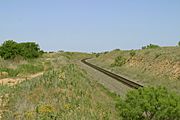
After a long climb, the BNSF railroad crosses the top of the Caprock Escarpment and extends onto the level plains of the Llano Estacado at Southland.
-
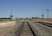
BNSF railroad tracks running across the level plains of the Llano Estacado on the east side of Southland.
-
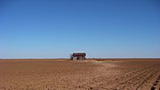
Abandoned farm building on the northeast side of Southland.


