
Southwark Christchurch facts for kids
Christchurch was an old local area in London, England. It was located south of the River Thames, near Blackfriars Road. This area started as a large estate called Paris Garden. It was originally part of a bigger area known as St Margaret, Southwark.
Later, in 1670, Paris Garden became its own separate area, or "parish," when a church called Christ Church was built there. For a long time, the area often flooded, so not many buildings were put up until after 1809.
In 1855, Christchurch became part of London's main city area. Its local government was changed. It joined with another area called St Saviour to form the St Saviour's District. In 1900, this district was removed, and Christchurch became part of the Metropolitan Borough of Southwark. Christchurch stopped being a separate parish in 1930. Today, it is the northwest part of the London Borough of Southwark.
| Christchurch Paris Garden |
|
 |
|
| Geography | |
| Status | Liberty Civil parish (1670–1930) |
| 1881 area | 77 acres (310,000 m2) |
| 1921 area | 77 acres (310,000 m2) |
| History | |
| Origin | Ancient manor |
| Abolished | 1930 |
| Succeeded by | Southwark |
Quick facts for kids Demography |
|
|---|---|
| 1881 population | 13,663 |
| 1921 population | 8,296 |
| Politics | |
| Governance |
|
Contents
What's in a Name?
The area was first called Wideflete in 1113. Later, in 1420, people started using the name "Parish Garden."
A street in the area is now called Paris Garden. It got this name in the early 1900s. Before that, it was known as Brunswick Street.
A Look Back at History
Early Days of Paris Garden
The Paris Garden estate was next to the old town of Southwark. It was part of a larger area called St Margaret. Even though it was outside Southwark, people usually thought of it as part of "Southwark."
This area had a special status called a "liberty." This meant it had its own rules. It was even possible to avoid arrest there, which gave the area a bit of a bad reputation.
In 1541, the St Margaret area became a new parish called St Saviour. In 1542, a man named William Baseley rented the Paris Garden estate. He was allowed to organize games like bowls and dice.
Paris Garden became famous for animal fights, like bear and bull baiting, for many years. These were popular but cruel events.
Becoming Christchurch Parish
In 1550, the City of London tried to control areas south of the Thames. But the special "liberties" of Clink and Paris Garden were not included.
In 1670, Christ Church was built. Because of the new church, Paris Garden was separated and became its own new parish, called Christchurch. From 1671, Christchurch was counted in the official records of deaths, called the Bills of mortality. Before this, it was part of St Saviour's records.
Changes in Local Government
When the Metropolitan Police started in 1829, Christchurch was part of their area. In 1831, it was listed as part of Southwark in the census. After 1832, it joined the Parliamentary Borough of Southwark.
For helping the poor, Christchurch joined with St Saviour in 1836. By 1855, Christchurch was considered too small to manage itself. This was despite its population almost doubling. So, it joined with St Saviour to form the St Saviour's District.
The Christchurch Vestry, a local council, sent 15 members to the St Saviour's District Board. This board then sent one member to the main Metropolitan Board of Works.
Joining the County of London
In 1889, Christchurch became part of the new County of London. The London County Council took over from the Metropolitan Board of Works.
In 1895, the Christchurch local council asked to join the City of London. In 1897, they tried again with other areas to join the City. But the City of London did not agree, and the plan failed.
In 1900, Christchurch became part of the Metropolitan Borough of Southwark. The new Southwark Metropolitan Borough Council took over from the old local councils. Christchurch continued to be used for electing poor law guardians until 1930.
Where Was Christchurch?
The northern edge of Christchurch was in the middle of the River Thames. This was between Old Barge House Stairs and Falcon Dock. When Blackfriars Bridge opened in 1769, the bridge itself was part of the City of London.
The rest of the boundary was a winding stream. The area was low and often flooded because it was part of the Thames floodplain. Not many buildings were constructed until after 1809. That's when the Surrey and Kent Commissioners for Sewers got the power to build proper sewers.
Population Changes (1801-1921)
Here's how the population of Christchurch changed over the years:
| Year | 1801 | 1811 | 1821 | 1831 | 1841 | 1851 | 1861 | 1871 | 1881 | 1891 | 1901 | 1911 | 1921 |
|---|---|---|---|---|---|---|---|---|---|---|---|---|---|
| Population | 9,933 | 11,050 | 13,339 | 13,705 | 14,616 | 16,022 | 17,069 | 14,573 | 13,663 | 13,264 | 11,263 | 9,514 | 8,296 |
Maps
-
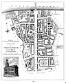
A map of Christchurch, Surrey
-
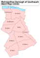
A map showing the Christchurch ward of Southwark Metropolitan Borough as it appeared in 1916


