
Spartansburg, Pennsylvania facts for kids
Quick facts for kids
Spartansburg, Pennsylvania
|
|
|---|---|
|
Borough
|
|

Methodist church on Main Street
|
|

Location of Spartansburg in Crawford County, Pennsylvania.
|
|

Spartansburg, Pennsylvania
Location in Pennsylvania

Spartansburg, Pennsylvania
Location in the United States
|
|
| Country | United States |
| State | Pennsylvania |
| County | Crawford County |
| Founded | 1830 |
| Area | |
| • Total | 0.69 sq mi (1.80 km2) |
| • Land | 0.66 sq mi (1.72 km2) |
| • Water | 0.03 sq mi (0.08 km2) |
| Elevation
(middle of borough)
|
1,450 ft (440 m) |
| Highest elevation
(southeast corner of borough)
|
1,640 ft (500 m) |
| Lowest elevation | 1,430 ft (440 m) |
| Population
(2020)
|
|
| • Total | 277 |
| • Estimate
(2022)
|
274 |
| • Density | 423.83/sq mi (163.62/km2) |
| Time zone | UTC-4 (EST) |
| • Summer (DST) | UTC-5 (EDT) |
| Area code(s) | 814 |
Spartansburg is a small town, called a borough, located in Crawford County in the northwestern part of Pennsylvania, United States. In 2020, about 277 people lived there. This was a slight decrease from 305 people counted in 2010.
Contents
Geography of Spartansburg
Spartansburg is found in the northeast corner of Crawford County. It is completely surrounded by Sparta Township, which is a separate local government area.
Route 77 goes right through the middle of Spartansburg. This road leads northeast about 8 miles (13 km) to Corry. If you go southwest, it's about 28 miles (45 km) to Meadville, which is the main town for Crawford County.
The United States Census Bureau says that Spartansburg covers a total area of about 0.69 square miles (1.83 square kilometers). Most of this area, about 0.66 square miles (1.76 square kilometers), is land. The rest, about 0.03 square miles (0.08 square kilometers), is water.
Natural Features Around Spartansburg
Spartansburg is located on a "glaciated plateau." This means the land was shaped by huge sheets of ice (glaciers) long ago.
The town is drained by the East Branch Oil Creek. This creek starts from Clear Lake, which is a lake formed by two smaller streams, Patrick Run and Stranahan Run. The lowest point in Spartansburg is 1,430 feet (436 meters) above sea level, where the East Branch Oil Creek flows out of the borough. The highest point is 1,640 feet (500 meters) at the southeast corner of the town.
Population History
| Historical population | |||
|---|---|---|---|
| Census | Pop. | %± | |
| 1860 | 235 | — | |
| 1870 | 457 | 94.5% | |
| 1880 | 486 | 6.3% | |
| 1890 | 516 | 6.2% | |
| 1900 | 488 | −5.4% | |
| 1910 | 460 | −5.7% | |
| 1920 | 450 | −2.2% | |
| 1930 | 374 | −16.9% | |
| 1940 | 423 | 13.1% | |
| 1950 | 482 | 13.9% | |
| 1960 | 500 | 3.7% | |
| 1970 | 464 | −7.2% | |
| 1980 | 403 | −13.1% | |
| 1990 | 403 | 0.0% | |
| 2000 | 333 | −17.4% | |
| 2010 | 305 | −8.4% | |
| 2020 | 277 | −9.2% | |
| 2022 (est.) | 274 | −10.2% | |
| U.S. Decennial Census | |||
The population of Spartansburg has changed over the years. In 1860, there were 235 people. The population grew to 516 by 1890, but then slowly decreased. By 2020, the population was 277.
In 2000, there were 333 people living in Spartansburg. These people lived in 130 households, and 93 of these were families. The average household had about 2.56 people, and the average family had about 3.06 people.
About 26.4% of the people were under 18 years old. About 15.9% were 65 years old or older. The average age in Spartansburg was 39 years.
Education
Students in Spartansburg attend schools in the Corry Area School District. The schools for older students include Corry Area Middle & High School.
Notable People from Spartansburg
- Ray Harroun: He was a famous race car driver who won the very first Indianapolis 500 race in 1911.
- Rebekah Byler: An Amish woman from Spartansburg.
Images for kids
-
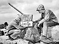
U.S. Marine Sgt. B.D. Boyant of Spartansburg (on the left), from the 4th Marine Division, sets up a post office on Iwo Jima in 1945.

See also
 In Spanish: Spartansburg para niños
