
East Branch Oil Creek (Oil Creek tributary) facts for kids
Quick facts for kids East Branch Oil Creek |
|
|---|---|


|
|
| Other name(s) | Tributary to Oil Creek |
| Country | United States |
| State | Pennsylvania |
| County | Crawford |
| City | Centerville Spartansburg |
| Physical characteristics | |
| Main source | Clear Lake in Spartansburg, Pennsylvania Spartansburg, Pennsylvania 1,441 ft (439 m) 41°49′29″N 079°41′07″W / 41.82472°N 79.68528°W |
| River mouth | about 0.1 miles west of Centerville, Pennsylvania Centerville, Crawford County, Pennsylvania 1,278 ft (390 m) 41°44′05″N 079°45′59″W / 41.73472°N 79.76639°W |
| Length | 10.88 mi (17.51 km) |
| Basin features | |
| Progression | south and southwest |
| River system | Allegheny River (Oil Creek) |
| Basin size | 59.8 square miles (155 km2) |
| Population | 3,256 (2010) |
| Tributaries | |
| Waterbodies | Clear Lake |
| Bridges | PA Route 77, PA Route 89, Britton Run Road, Garland Street, PA Route 8 |
East Branch Oil Creek is a stream located in Crawford County, Pennsylvania, in the United States. It flows for about 10.9 miles (17.5 kilometers) and is a smaller stream that feeds into a larger one called Oil Creek. This stream is an important part of the bigger Allegheny River system.
Contents
Where Does East Branch Oil Creek Flow?
The East Branch Oil Creek starts in a place called Clear Lake. This is where two smaller streams, Stranahan Run and Patrick Run, join together.
From Clear Lake, the stream flows generally south and then southwest. It travels through an area known as the Erie Drift Plain. Finally, it reaches the town of Centerville, Pennsylvania, where it meets and joins Oil Creek.
What Are the Smaller Streams That Join It?
Many smaller streams, called tributaries, flow into the East Branch Oil Creek along its journey. These tributaries add water to the main stream. Here are some of the important ones:
Understanding the East Branch Oil Creek Area
The land area that drains water into East Branch Oil Creek is called its watershed. This watershed covers about 59.8 square miles (155 square kilometers).
The area gets a good amount of rain and snow, about 46 inches (117 centimeters) each year. The average water temperature in the stream is around 7.56 degrees Celsius (45.6 degrees Fahrenheit). About 49% of the land in this watershed is covered by forests.
Images for kids
-
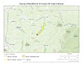
The path of East Branch Oil Creek.
-
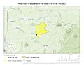
A map showing the watershed of East Branch Oil Creek.
.jpg)
.jpg)
